Humberto, the eighth named storm of the 2025 Atlantic hurricane season, intensified into a hurricane late Thursday night. Fortunately for South Florida residents, meteorologists do not anticipate any significant impacts from this storm.
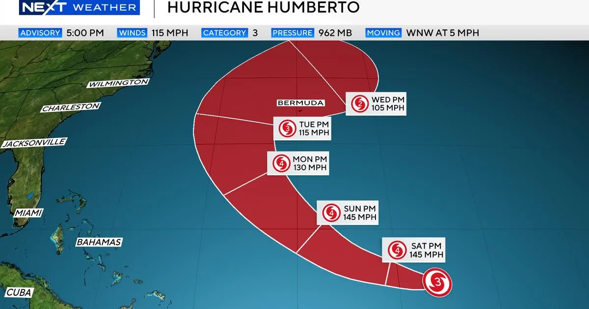
As of 11 p.m. on September 26, Humberto is situated approximately 390 miles northeast of the Northern Leeward Islands. The storm is moving northwestward at a speed of 7 mph, with maximum sustained winds reaching up to 145 mph. This rapid intensification has elevated Humberto to a Category 4 hurricane, similar to the other hurricanes that have formed this season.
As Humberto shifts its trajectory to the north, residents of Bermuda are on alert. The storm's path continues to be monitored closely by meteorologists, ensuring that the community is prepared for any potential impacts.
In addition to Humberto, there is a tropical disturbance located north of Haiti and the Dominican Republic. This system has yet to develop a closed center, meaning it has not been classified as a tropical depression or tropical storm. However, the National Hurricane Center has activated its new protocol to issue advisories for systems that may threaten land within 72 hours, even if they haven't formally developed. This is referred to as a potential tropical cyclone.
A tropical cyclone is a general term that encompasses all stages of storm development, including tropical depressions, tropical storms, and hurricanes. With the establishment of the familiar cone, state and local officials can begin coordinating with emergency managers to determine necessary protocols. For residents, understanding the storm's projected path helps anticipate any potential effects, even if South Florida is not directly in the storm's cone.
While South Florida is not expected to be directly impacted by Humberto, residents should be aware of the typical marine hazards associated with hurricanes. Indirect effects may include rough boating conditions and an increased risk of rip currents. It's important to note that the system's future, potentially named Imelda, could bring outer rain bands to Florida's east coast on Sunday, though this scenario remains less likely.
The 2025 Atlantic hurricane season has been characterized by expectations of above-normal activity. The National Oceanic and Atmospheric Administration (NOAA) anticipates between 13 and 18 named storms, with five to nine projected to develop into hurricanes. Thus far, the only storm to reach hurricane status this season has been Erin, which achieved a peak intensity of Category 5 without making landfall, yet still caused significant winds, dangerous rip currents, and flooding along parts of the East Coast.
As the hurricane season progresses, it is essential to stay informed about potential changes in storm paths and intensities. Regular updates can be found through local news broadcasts and online platforms. Always ensure that your hurricane preparedness plan is current to safeguard yourself and your family in the event of an approaching storm.