Tropical Storm Imelda is currently intensifying north of the Bahamas and is beginning its significant eastward turn, thus sparing the U.S. coastline from a direct impact. Nevertheless, the storm continues to create hazardous conditions, including dangerous surf, rip currents, coastal flooding, and beach erosion along the Southeast coast. This situation is compounded by the presence of Hurricane Humberto, which is also affecting the region.
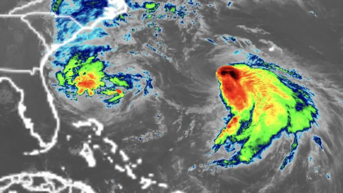
Bermuda is facing a rare challenge as it prepares for a one-two punch from both Hurricane Humberto and Tropical Storm Imelda this week. Humberto briefly escalated to a rare Category 5 storm with winds reaching 160 mph last Saturday but has since downgraded to a large Category 2 hurricane. Currently located just a few hundred miles east of Imelda, Humberto's extensive size is predicted to exacerbate hazards along U.S. beaches this week, generating deadly rip currents and significant waves that will extend farther north along the East Coast than Imelda would have caused alone.
As of early Tuesday, Tropical Storm Imelda had sustained winds of 70 mph and was situated approximately 750 miles west-southwest of Bermuda, according to the National Hurricane Center. The storm is anticipated to reach hurricane strength later on Tuesday. Despite remaining offshore, Imelda has already had tragic consequences. A 51-year-old man drowned in Volusia County, Florida, after being swept into the ocean by rip currents, as reported by the sheriff’s office. Additionally, in Cuba, two fatalities were reported, including a 60-year-old man who died when his home collapsed due to a landslide triggered by heavy rain.
Localized flash flooding remains a concern in the coastal Carolinas through Tuesday. Most areas can expect approximately 2 inches of rain, with localized regions potentially receiving up to 4 inches across southeast North Carolina. Coastal flooding is also a possibility from Florida’s Space Coast to North Carolina’s Outer Banks, where onshore winds could push water levels 1 to 2 feet above typically dry ground during high tide.
As Tropical Storm Imelda prepares to make a sharp right turn due to the influence of Humberto, the threat of flooding rain and damaging winds for the U.S. is decreasing compared to concerns raised over the weekend. So far this year, the U.S. has evaded a direct hurricane landfall, with Tropical Storm Chantal making landfall in South Carolina this July but no hurricanes reaching the coast at hurricane strength in 2025. If this trend continues, it would mark the first season without a hurricane making landfall in a decade.
This hurricane season has been notable for another reason: all hurricanes so far—Erin, Gabrielle, and Humberto—have achieved major strength, a feat not observed this early in the season since 1935. Major hurricanes are classified as Category 3, 4, and 5 storms. Rapid intensification of storms has become increasingly common in recent years due to climate change and fossil fuel pollution.
Bermuda is in a precarious position as it braces for the impact of twin storms this week. Humberto is currently passing west of the island, bringing bands of rain, gusty winds, and hazardous surf. Following closely behind, Tropical Storm Imelda is expected to track even nearer to Bermuda, with the potential for a direct landfall and up to 4 inches of rain anticipated from Wednesday into Thursday. In light of these developments, the Bermuda Weather Service issued a hurricane watch for the archipelago on Monday afternoon. The combination of two hurricanes within a week could deliver a severe blow to the already storm-tested islands.