An incredibly dangerous day of severe thunderstorms, including the potential for long-lasting, powerful tornadoes and hurricane-strength wind gusts, is ahead for the eastern half of the United States this Friday. The escalating threat for tornadoes and damaging winds follows a destructive storm system that already wreaked havoc in the Midwest and Great Lakes on Thursday. This event is part of a multi-day threat of widespread severe weather that is expected to extend into early next week.
As of early Friday morning, some severe thunderstorms from Thursday night were still active from Arkansas through Kentucky. However, these storms are anticipated to dissipate quickly, allowing the atmosphere to recharge for another, more violent round of storms beginning in the afternoon. According to the Storm Prediction Center (SPC), “a regional outbreak of severe thunderstorms is likely this afternoon into tonight,” warning that some individuals in the storm's path may encounter “intense supercells.”
More than 70 million people in the eastern half of the U.S. are currently under at least a level 2-of-5 threat for severe thunderstorms on Friday. The greatest risk for long-lasting, EF3-plus tornadoes and widespread damaging winds is concentrated in parts of the Mississippi and Ohio Valleys. The National Weather Service in Louisville, Kentucky, has issued warnings stating, “All severe weather hazards are on the table, including damaging winds, large hail, tornadoes, and torrential rainfall.” They also noted that “a few strong tornadoes and instances of very large hail are possible.”
Storms are expected to ignite in regions of Missouri, Arkansas, and Illinois during the afternoon, rapidly expanding toward the east. The initial storms are the most likely to develop into supercells capable of generating tornadoes, damaging wind gusts, and large hail. This threat will persist into the evening, with some storms forming unbroken lines. As these storms develop, the wind threat will escalate, with gusts exceeding 75 mph, potentially causing damage across hundreds of miles.
Dangerous storms are likely to continue after dark, particularly affecting parts of Kentucky and areas farther east. This is a significant concern, as nighttime tornadoes are nearly twice as deadly as those that occur during the day, as indicated by a 2022 study.
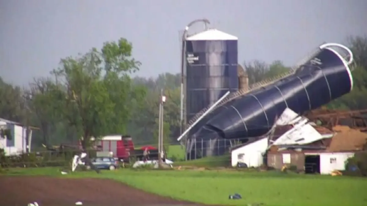
On Thursday, at least 11 tornadoes were reported across Minnesota, Wisconsin, and Illinois as thunderstorms surged through the Midwest. Significant damage was documented in Dodge County, Wisconsin, where a cluster of storms prompted shelter-in-place alerts and forced residents to evacuate, according to Sheriff Dale Schmidt. One person was hospitalized with injuries in Juneau, and the sheriff mentioned that there “may have been another minor injury or two.”
Numerous streets and highways in the county remain closed due to downed power lines and fallen trees, with multiple homes in Juneau suffering damage, including at least one house that experienced a roof collapse. Fortunately, everyone inside was able to evacuate safely.
Powerful winds also affected multiple states, with a weather reporting station on Lake Michigan near Chicago's Navy Pier recording a hurricane-strength wind gust of 79 mph. By Friday morning, nearly 400,000 homes and businesses across five Midwest states were without power, including over 250,000 in Michigan, as reported by PowerOutage.us. Michigan utility company Consumers Energy stated that assessments for power restoration were still pending, according to CNN affiliate WNEM.
As the storm system continues its eastward movement, severe thunderstorms are possible in the Mid-Atlantic and Northeast regions on Saturday. The primary threats are damaging wind gusts and hail, although tornadoes cannot be ruled out. New storms may also bring damaging winds, hail, and tornadoes to parts of the southern Plains starting Saturday afternoon.
The Plains will remain the main focus for severe weather into Sunday and Monday, with damaging storms expected in much of Oklahoma and Kansas. The severe thunderstorm threat is projected to shift back into parts of the Mississippi Valley on Tuesday. More details regarding the specific risks posed by these storms and the populations at risk will become clearer in the upcoming days.