Weather officials issued urgent warnings late Sunday regarding the potential for significant and life-threatening flooding in southern Minnesota. The National Weather Service (NWS) has declared a flood watch effective from 7 p.m. Sunday to 7 a.m. Monday across western, central, and southern Minnesota. Additionally, a separate watch is in place for the Twin Cities, southeastern Minnesota, and western Wisconsin from 10 p.m. to 10 a.m. During this period, rainfall amounts between 1 and 2 inches are anticipated, with localized totals possibly exceeding 4 inches. The situation is further complicated by the risk of severe thunderstorms and tornadoes.
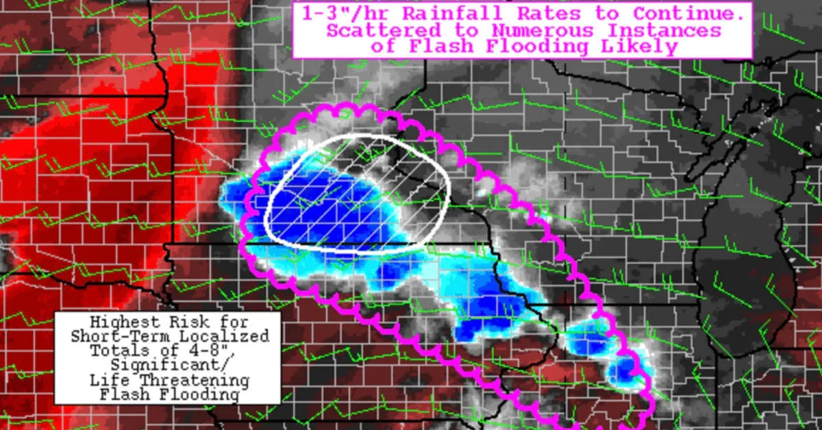
As of late Sunday evening, the NWS Mesoscale Precipitation Discussion raised alarms about the imminent flooding risk, particularly in south-central and southeastern Minnesota. Rainfall rates of 1-3 inches per hour are expected to persist overnight, potentially leading to localized totals of 4-8 inches. The areas facing the highest risk of flooding include much of the Twin Cities, specifically Hennepin, Ramsey, Dakota, Scott, Carver, and Washington counties, along with parts of Anoka County.
The weather forecast indicates that the current storm system over the Twin Cities may linger until past midnight, continuing to deliver substantial rainfall to the metro area. According to the HRRR model, additional storm cells are likely to develop in central Minnesota and the Twin Cities around 3 a.m. A larger system is predicted to enter southwestern Minnesota by 4 a.m. and reach the Twin Cities by approximately 8 a.m. This means a wet and potentially hazardous commute for Minnesotans on Monday morning, with continuous rain expected from 4 a.m. to 10 a.m. in the metro area.
A flash flood warning is currently in effect for areas including Faribault and Red Wing. The NWS has also reported ongoing urban flooding in the Twin Cities, which is likely to persist until midnight. A slow-moving line of thunderstorms is generating heavy rainfall rates of approximately 2 inches per hour as it moves northeast. Residents are strongly advised to avoid driving or walking in flooded areas.
The NWS has issued a special weather statement for the Twin Cities, indicating that while the next system is not expected to bring severe weather, gusty winds of up to 40 mph could occur in suburbs like Eden Prairie, Minnetonka, and Edina. A flash flood warning has also been activated for the Owatonna area, affecting communities such as Blooming Prairie and Waseca until 2:30 a.m., where extremely heavy rainfall has already been reported.
As of 9:05 p.m., a severe thunderstorm warning was issued for the southwest Twin Cities metro, including Prior Lake and Savage, with potential wind gusts reaching 60 mph. In the Mankato area, conditions have warranted another severe thunderstorm warning, predicting gusts of up to 60 mph and pea-sized hail. Tornado warnings have also been issued for southern Minnesota, impacting regions like Frost and Winnebago.
Officials emphasize the importance of being prepared for flash flooding, as soil and local waterways are already saturated from previous rainfall. The Twin Cities metro experienced up to 4 inches of rain from storms earlier in the week, and additional heavy rainfall could lead to significant flooding in low-lying and flood-prone areas. Residents should stay informed through local weather updates and remain cautious during severe weather events.
For ongoing updates and alerts, consider signing up for our BREAKING WEATHER newsletters to stay safe during this severe weather situation.