Recent satellite images have unveiled significant damage to key missile sites in Iran, following Israeli airstrikes that have escalated tensions between Iran and Israel. The analysis, conducted by experts from Maxar Technologies, indicates that structures at two missile bases and an airport runway have been critically affected.
In the ongoing conflict, satellite imagery serves as a vital tool for understanding the situation on the ground, particularly in regions like Iran, where access for journalists is severely restricted. The latest images highlight a missile base operated by Iran's Islamic Revolutionary Guard Corps (IRGC) located in the western province of Kermanshah. High-resolution images captured on June 15 reveal extensive damage to multiple buildings within the facility.
The satellite images indicate that several structures at the Kermanshah base have been completely destroyed, with debris scattered across the site. Notably, damage has also been observed at two tunnel entrances set against the mountainside, likely utilized for storing sensitive military equipment. Iran's ballistic missiles are typically concealed in underground silos throughout the country, emphasizing the strategic importance of these facilities.
Jeremy Binnie, a Middle East specialist at Janes Defence Intelligence, highlights that the targeted buildings may include barracks, suggesting an effort to diminish the number of personnel available to operate missile launchers for potential retaliatory strikes. Kermanshah, recognized as one of Iran's oldest ballistic missile bases, has been instrumental in various missile operations, including targeted strikes against armed groups and Israel.
In addition to the Kermanshah missile base, satellite images from Planet Labs reveal substantial damage at the international airport in Tabriz, the capital of Iran's East Azerbaijan province. Images taken on June 14 show a large scorched area at the center of the main runway, along with damage to two taxiways where they intersect with the runway. Although the operational status of the airport remains unclear, flight tracking services such as Flightradar24 indicate no commercial flights have arrived or departed since early Friday, coinciding with the initial Israeli strikes.
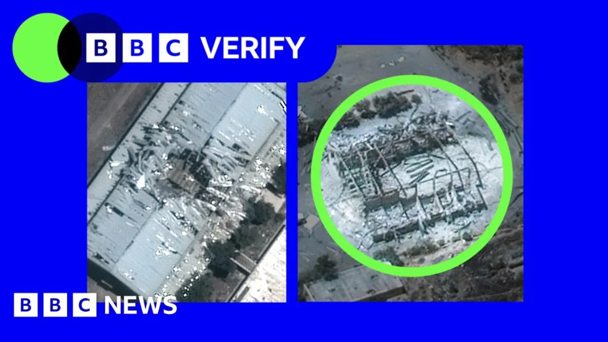
About 30 kilometers (19 miles) west of Tehran, the Bid Kaneh facility has faced serious damage in the past. A Maxar image from June 15 shows significant destruction, including a penetrated roof on a large structure. This facility was previously the site of a catastrophic explosion in 2011, which Iranian authorities attributed to an accident, although there were speculations regarding possible sabotage related to Iran's missile program.
Moreover, satellite images from the EU's Sentinel-2 satellites captured on June 15 reveal large plumes of smoke emanating from two energy facilities in Tehran. The Shahr Rey refinery, one of Iran's largest, is capable of refining 225,000 barrels per day. The second site, the Shahran oil and gas depot, serves as a critical hub for fuel distribution in northern Tehran. Damage has been reported at multiple structures within these facilities.
Despite the visible destruction, Iranian officials have downplayed the significance of these strikes. The oil ministry's news agency, Shana, reported that the situation remains under control, stating that the containers at Shahran were not full when struck and that the refinery continues to operate normally. The ongoing conflict and the implications of these attacks highlight the delicate balance of power in the region.
As tensions between Iran and Israel persist, further developments are anticipated, and the role of satellite imagery will remain crucial in uncovering the realities of the situation.