Hurricane Melissa is making its presence felt as its northern eyewall begins to move ashore in southern Jamaica. This critical region, known for housing the storm's most extreme and devastating winds, is currently experiencing gusts of up to 180 mph. The official landfall is anticipated when the center of the eye crosses the coastline, likely occurring later this morning or early afternoon. Residents across Jamaica are preparing for one of the most powerful storms the island has ever faced.
Robert H.P. Hill, the CEO of the Kingston and St Andrew Municipal Corporation, has been actively involved in efforts to ensure the safety of citizens. In an interview with CNN’s John Berman, Hill described witnessing the intensifying winds from his waterfront office while his team implemented crucial safety measures. He highlighted that flooding poses one of the greatest risks to Jamaica, particularly in low-lying regions.
To mitigate flooding risks, teams have been clearing drains, gullies, and waterways. Independent journalist Jonathan Petramala, reporting from Jamaica, warned that heavy rainfall could rush down the mountains like a “water slide,” potentially causing severe flooding in coastal areas. He advised residents to stay away from water sources due to the anticipated storm surges along the coastline.
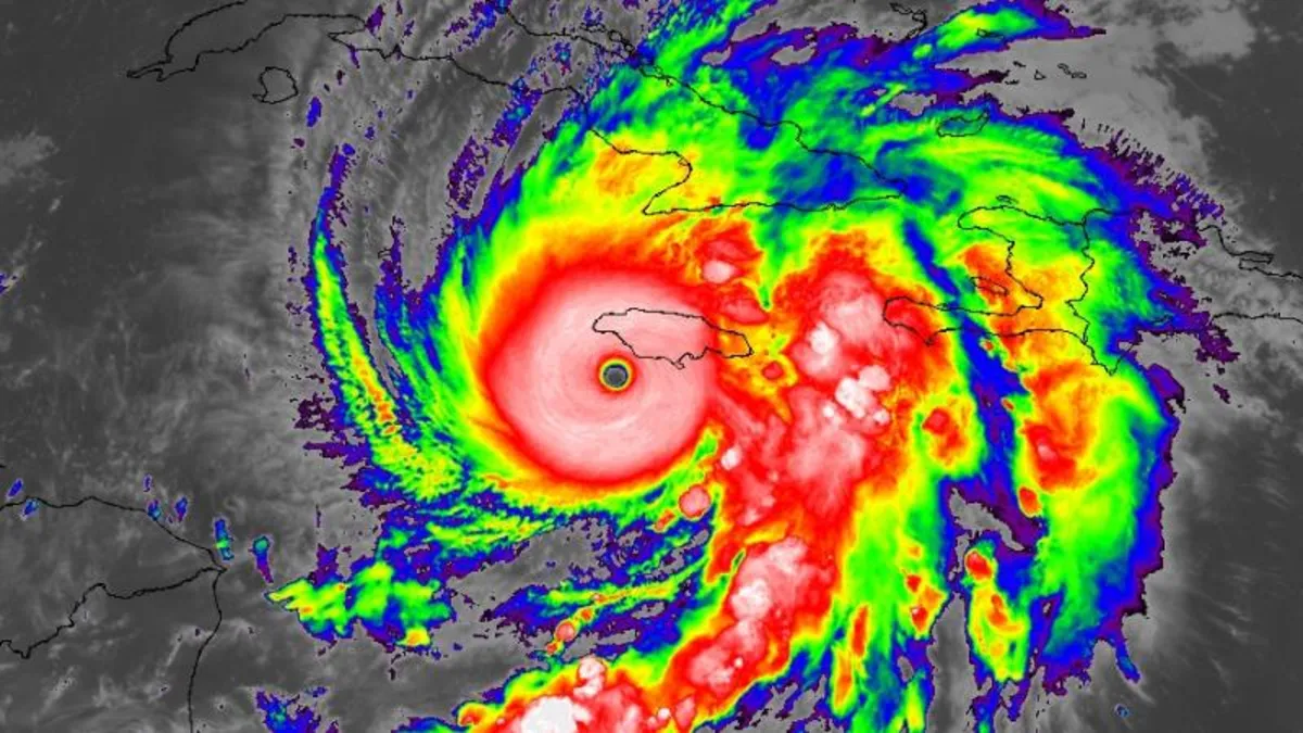
As the sun rose, a stunning satellite image revealed the majestic yet terrifying sight of Hurricane Melissa from space. The phenomenon known as the “stadium effect” was evident in the storm’s eye, where towering clouds resemble circular seating in a sports arena. This is a common occurrence in powerful hurricanes, attributed to rapid air movement near the eye, resulting in a bowl-shaped appearance visible to satellite imagery and the Hurricane Hunters monitoring the storm.
Brian Trascher, vice president of the US-based non-profit organization United Cajun Navy, shared grave concerns as conditions in Jamaica are "deteriorating rapidly." In his conversation with John Berman on CNN, he indicated that evacuation efforts have become increasingly difficult as the storm shifted west before stalling. Trascher urged residents to prepare for the imminent devastation, stating that no amount of caution would be excessive. He cautioned that wind speeds would be life-threatening, with loose objects becoming dangerous projectiles.
Additionally, Trascher warned of potential landslides and advised individuals to seek shelter in concrete structures, preferably on the leeward side of hills, to avoid the rushing waters and debris.
Here is a summary of the current situation regarding Hurricane Melissa:
Melissa is moving north-northeast at 7 mph and is expected to make landfall in Jamaica later this morning. The storm has maintained its Category 5 status for over 24 hours, with peak wind speeds reaching 175 mph. UN officials have described Melissa as “the storm of the century,” with a potential storm surge of up to 13 feet. A hurricane warning is currently in effect for various regions, including Cuba and the Bahamas. Over 800 shelters have been opened across Jamaica for residents in need of refuge from flooding and landslides.Maritza Caver-Blake and her husband Maurice, who are currently in Jamaica celebrating their 10th wedding anniversary, shared their experiences as they prepare for the storm. After their flight home to Arkansas was canceled, they were instructed to pack emergency bags containing important documents. They expressed their concern for their family back home and their hopes to return soon.
As Hurricane Melissa approaches, it is expected to become the first Category 5 hurricane to make landfall in the Atlantic basin in over six years, marking a historic moment for Jamaica. The hurricane center has warned of impending catastrophic hurricane-force winds beginning in the coming hours, with Melissa positioned just 55 miles south-southeast of Negril, Jamaica.
The last recorded Category 5 hurricane to make landfall in the Atlantic was Hurricane Dorian in September 2019, which struck the Bahamas with winds up to 185 mph. The most powerful storm to hit Jamaica previously was Hurricane Gilbert, which made landfall as a Category 4 hurricane with winds of 130 mph in 1988.
As Melissa nears Jamaica, an eyewall replacement cycle may be underway, which often causes temporary weakening of winds. However, experts believe that any diminishment in strength will not significantly lessen the danger posed by the storm. The World Meteorological Organization anticipates a catastrophic impact on Jamaica, projecting storm surges of up to 13 feet and rainfall accumulating as much as 40 inches.
Jamaica's climate minister has cautioned that over 1.5 million people could be directly affected by Hurricane Melissa, emphasizing the government's preparedness measures in response to previous storms. With 70% of the population living within 3.1 miles of the sea, extreme flooding risk remains a pressing concern.
Hurricane Melissa’s intensification has been fueled by unusually high ocean temperatures in the Caribbean. The storm experienced rapid intensification, with its maximum sustained winds escalating from 70 mph to 175 mph in just a few days, highlighting a troubling trend linked to climate change.
As Jamaica braces for the arrival of Hurricane Melissa, communities are urged to remain vigilant and adhere to safety protocols. The storms of this magnitude pose significant threats, and the population must prepare for the potential aftermath of flooding, intense winds, and landslides.