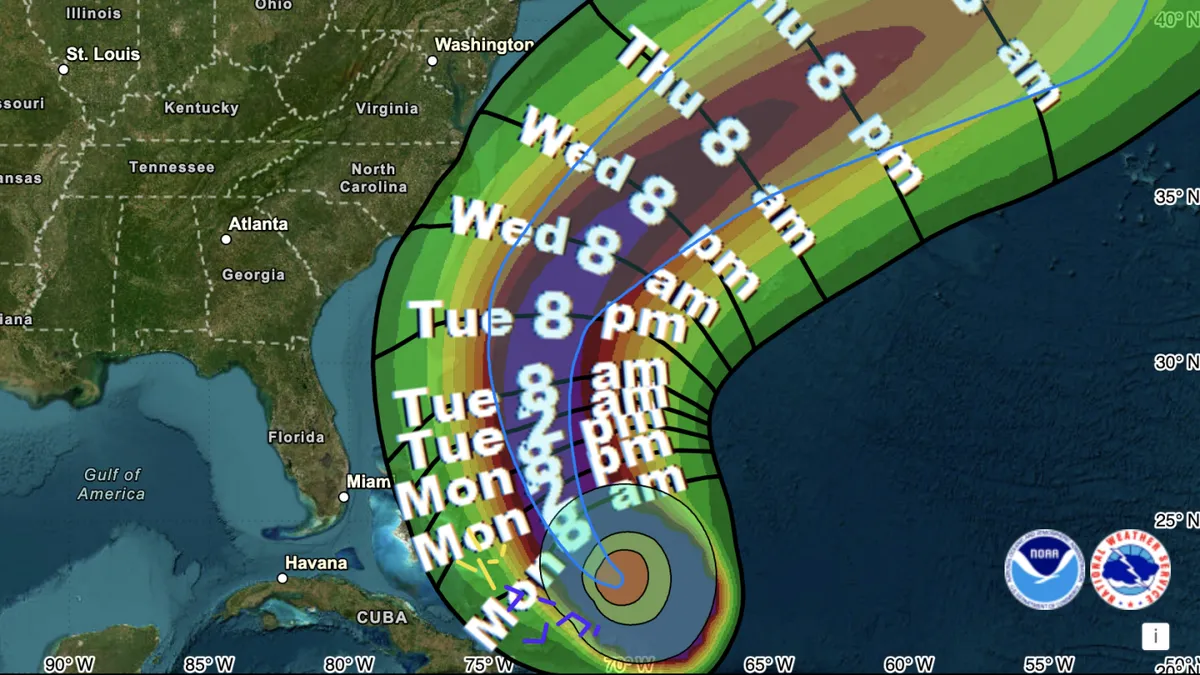
Hurricane Erin is currently intensifying as it moves toward the Bahamas and the U.S. East Coast, exhibiting sustained winds nearing 140 mph. According to the National Hurricane Center, this major hurricane is expected to generate life-threatening surf and rip currents along many beaches on the East Coast for the next several days, prompting evacuation orders in vulnerable areas.
Although Hurricane Erin is not predicted to make landfall in the U.S., forecasters from the National Weather Service office in Morehead City, North Carolina, have advised residents in areas like the Outer Banks to brace for waves that could reach heights of 15 to 20 feet. The potential for dangerous flooding is significant, with coastal flooding expected to be a prolonged issue that may affect Highway 12, the primary route along the Outer Banks. This situation could render parts of the highway impassable for several days.
The North Carolina transportation department has issued a mandatory evacuation order for all visitors to Ocracoke and Hatteras Islands, with the order for residents set to take effect early Tuesday. Additionally, officials in Hyde County, North Carolina, have declared a state of emergency for Ocracoke Island, cautioning that emergency vehicles may be unable to access Highway 12 to assist those in distress. To the north, Dare County has also declared a state of emergency for the entire region.
As of the latest update from the hurricane center at 2 p.m. ET, Hurricane Erin is located approximately 140 miles north of Grand Turk Island and is moving west-northwest at a speed of 10 mph. The storm has been expanding, with hurricane-force winds reaching up to 80 miles from its center and tropical-storm-force winds extending as far as 230 miles. The Turks and Caicos Islands are currently experiencing waves over 10 feet and sea swells ranging from 8 to 12 feet, occasionally peaking at 17 feet, prompting a tropical storm warning and a flood alert due to heavy rains.
Despite the forecast indicating that Hurricane Erin may not directly impact the U.S. mainland, the storm significantly raises the risk of tall waves and perilous rip currents along the eastern coastline, stretching from Florida to Massachusetts. Forecasts predict that tropical-storm-force winds may only directly affect a small portion of the U.S. mid-week, with the risk area primarily focused on the Outer Banks. As the storm progresses northward, both Bermuda and Canada may also face associated hazards.
The core of the Category 4 hurricane is expected to move east of the southeastern Bahamas today and travel between Bermuda and the U.S. east coast by mid-week. The National Hurricane Center predicts that Erin will gradually turn northwest on Monday and then north on Tuesday. Although the hurricane has weakened slightly from its peak as a Category 5 storm with winds nearing 160 mph, forecasters anticipate that Erin will continue to grow as it nears the U.S., expanding its potential to induce flooding and other impacts.
Experts note that climate change is contributing to the increasing intensity of hurricanes, with warmer air and ocean temperatures providing more fuel for extreme weather events. This trend raises the risk of flooding, which remains the leading cause of fatalities associated with hurricanes. Notably, Hurricane Erin is the first storm of the Atlantic season to reach hurricane status, signaling a potential acceleration in storm activity after a relatively slow start to the 2025 hurricane season. The hurricane center is also monitoring a tropical wave over the eastern Atlantic that may develop into a storm within the next week.