After a remarkable surge in intensity, Hurricane Erin has escalated into a sprawling Category 4 storm in the Atlantic. This powerful storm is generating significant concern due to its extensive footprint, which poses threats of life-threatening rip currents and towering waves directed at the eastern United States coastline and Bermuda. Although the storm is expected to remain well offshore, its expansive wind field is already producing large swells that extend hundreds of miles, leading to dangerous rip currents along US shores as Erin prepares to shift northward.
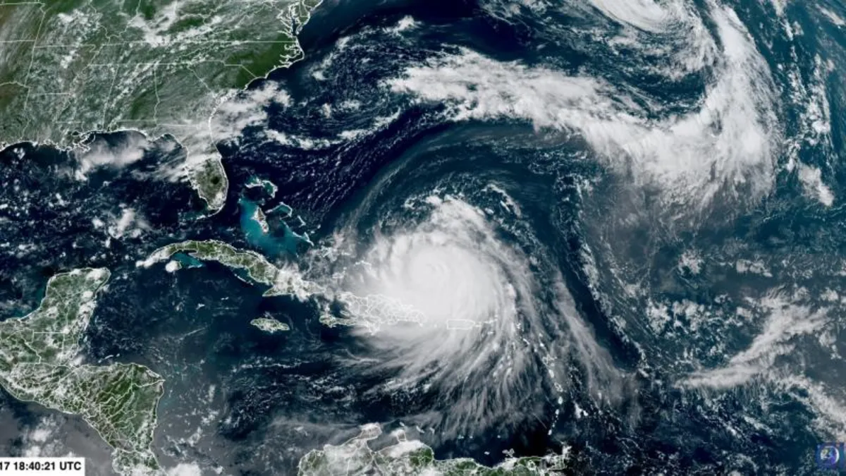
The outer rain bands of Hurricane Erin have already impacted Puerto Rico, resulting in flash flooding and power outages. The storm is also beginning to affect the southeast Bahamas and the Turks and Caicos Islands early Monday, as reported by the National Hurricane Center. Starting Tuesday, large swells from Erin are set to reach much of the East Coast and Bermuda, with conditions likely worsening throughout midweek. “Even though Erin is expected to remain far offshore, the threat to life from rip currents and high surf along our beaches is very real,” warned the National Weather Service office in Morehead City, North Carolina, in a beach hazards statement.
Forecasts indicate that Erin will curve north-northeast between the US East Coast and Bermuda in the coming days, remaining offshore while potentially strengthening and expanding further in size. This means the storm's influence will be felt indirectly, manifesting through large surf, hazardous currents, and coastal flooding during high tides. Dare County in North Carolina, home to the Outer Banks, declared a local state of emergency on Sunday, including a mandatory evacuation order for Hatteras Island. “Coastal flooding and ocean overwash are expected to begin as early as Tuesday, August 19, 2025, and continue through Thursday, August 21, 2025,” stated a news release, indicating that portions of N.C. Highway 12 may be impassable for several days.
Bermuda also lies in Erin’s path, with forecasters predicting very rough seas and possibly tropical storm–force winds later this week. As the storm approaches, the rip current risk along the US East Coast—from South Carolina to the Delmarva Peninsula and the New Jersey shore—is expected to escalate sharply from Tuesday through Thursday, even amidst clear skies. Tragically, 44 individuals have lost their lives to rip currents and other surf-zone hazards in the US this year, underscoring the severe risks associated with these natural phenomena.
Officials are urging beachgoers to stay out of the water during rip current alerts. In its evacuation order, Dare County Emergency Management emphasized, “This is not the week to swim in the ocean. The risk from surf and flooding will be life-threatening.” The outer bands of Erin continue to deliver heavy rainfall across Puerto Rico, with up to 2 inches expected through Monday night, resulting in significant power outages affecting around 100,000 residents, as reported by Governor Jennifer González-Colón. The National Hurricane Center also forecasts an additional 6 inches of rainfall over the Turks and Caicos and eastern Bahamas through Tuesday, raising concerns for flash flooding, landslides, and mudslides.
Hurricane Erin's rapid impact began over the weekend when it experienced one of the fastest intensification bursts on record in the Atlantic, escalating from tropical storm strength to a Category 5 in just over a day, peaking at nearly 165 mph. This rapid strengthening was fueled by exceptionally warm waters and favorable atmospheric conditions. The storm then eased to Category 3 while undergoing an eyewall replacement cycle, a process that usually allows storms to grow larger despite temporary dips in wind speed. With the completion of this cycle, Erin has re-intensified to Category 4, broadening its wind field and expanding the area at risk for dangerous surf and rip currents.
Hurricane Erin marks the first hurricane of the Atlantic season. Before Erin, four other systems—Andrea, Barry, Chantal, and Dexter—traversed the Atlantic basin, but none reached hurricane status. Meteorologists are closely monitoring a tropical wave trailing Erin that has a medium chance of developing into a tropical depression or storm in the coming week. Although it is premature to predict this system's trajectory, forecasters remain vigilant, especially as sea surface temperatures continue to hover above average despite Erin stirring cooler waters beneath the surface.
As the Atlantic hurricane season progresses, Erin serves as a stark reminder of the potential for rapid storm intensification in a warming climate. The unusual occurrence of a Category 5 storm forming early in the season, particularly outside the Gulf of Mexico, emphasizes the need for preparedness and caution as we navigate through this unpredictable period.