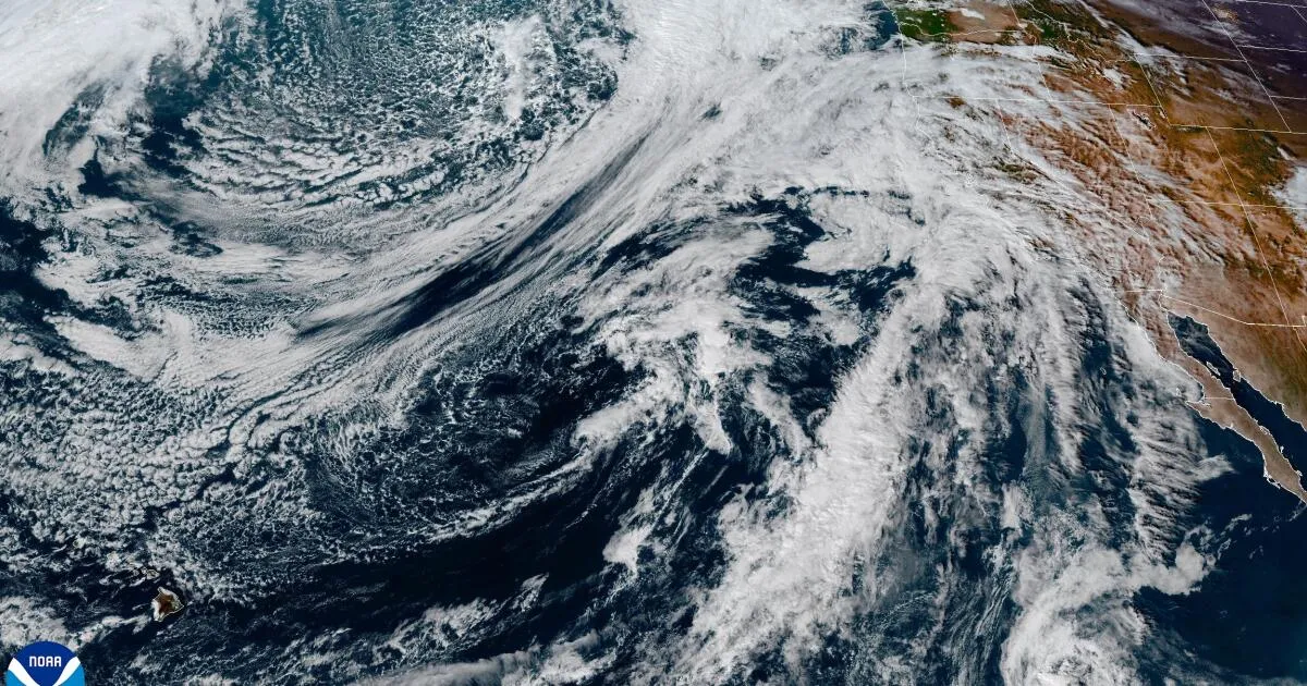
A fast-moving atmospheric river is forecasted to strike California this week, bringing potential hazards including heavy rainfall, flooding, and debris flows, particularly in areas recently affected by wildfires. This storm system is expected to arrive in Northern California on Wednesday, subsequently reaching Southern California by Thursday and persisting through Saturday.
Forecasters predict that the storm could deliver the most substantial rainfall downtown Los Angeles has experienced in over a month, possibly even since February. Rose Schoenfeld, a National Weather Service meteorologist in Oxnard, warned of the possibility of flash flooding and debris flow issues in burn areas, stating, "A flood watch will be possible for burn scars." While the storm poses risks, it may also signify the end of the autumn fire season, with rain in Northern California already reducing seasonal fire danger.
The National Weather Service in Oxnard described the upcoming storm as "potentially significant," indicating that roadways may flood, rockslides could occur on canyon roads, and mudflows are a concern. Traffic disruptions are anticipated in Los Angeles and Ventura counties, especially during Thursday afternoon and Friday commutes, potentially leading to water accumulation on roadways.
In the Los Angeles area, rainfall estimates suggest 1 to 2 inches along the coast and in the valleys, with 2 to 4 inches likely in mountainous and foothill regions. Schoenfeld noted, "We’re looking at moderate to locally heavy rain rates with this system." Specific rainfall predictions include:
Long Beach: 1.08 inches Downtown Los Angeles, Redondo Beach, Pomona, Pasadena: approximately 1.3 inches Oxnard: 1.51 inches Santa Clarita: 1.75 inches Westlake Village: 1.98 inches Santa Barbara: 2.22 inches Ojai: 2.88 inchesWind gusts could also pose a challenge, with forecasts predicting peak speeds of up to 50 mph along the Grapevine section of the 5 Freeway and in the Antelope Valley. In downtown Los Angeles, gusts may reach 21 mph, while areas like Long Beach could see 24 mph, and Santa Clarita may experience gusts of 26 mph.
Rainfall rates are expected to vary widely, with most areas experiencing between 0.25 to 0.5 inches per hour. In mountainous regions, this could rise to 0.5 to 0.75 inches per hour, with certain locations potentially receiving up to an inch per hour. The Santa Ynez Mountains in Santa Barbara County and the mountains in western Ventura County are particularly susceptible to significant debris flows due to recent burn scars. The National Weather Service indicated that “if models stay consistent, a flood watch will likely be issued for vulnerable areas.”
This storm will also lead to a dramatic drop in temperatures across California. Downtown Los Angeles, which saw a high of 92 degrees on Monday, is expected to plummet to 61 degrees by Friday. Similar temperature declines are anticipated in Anaheim and San Diego. Wind gusts of up to 60 mph may affect driving conditions, especially for taller vehicles, particularly in flood-prone areas.
Officials emphasize that while this storm is significant, they are not advising residents to stay off the roads entirely. However, individuals living in areas prone to flooding, such as canyon and mountain passes, should exercise caution.
The upcoming storm could play a crucial role in shaping California’s fire season. According to David Gomberg, NWS fire program manager, the expected rain might lead to a significant reduction in fire risks, contingent on the storm totals. Typically, officials look for widespread rain totals of 3 to 4 inches in lower elevations to officially declare the end of the fire season.
Recent rainfall in downtown Los Angeles, which recorded 1.38 inches on October 14, has already contributed to mitigating fire risks. The last time the city experienced more than an inch of rain was on March 13, when it recorded 1.03 inches. The wettest day this year was February 13, with 2.8 inches of rain.
After the anticipated rainfall ends on Friday, further showers may affect Los Angeles starting Saturday. However, the exact precipitation amounts remain uncertain due to the development of a "cut-off low pattern," which complicates forecasting. Schoenfeld cautioned that this pattern can significantly impact rainfall predictions.
Additionally, thunderstorms are possible across a vast region of California, potentially bringing gusty winds, heavy downpours, and even small hail. The San Francisco Bay Area is expected to experience its most intense rainfall late Wednesday and Thursday, with Sacramento potentially receiving up to 2 inches of rain.
The storm may also bring heavy snowfall to the Sierra Nevada, with meteorologists advising against travel from Thursday morning to Friday morning. Donner Peak could see between 12 to 18 inches of snow, and motorists may be required to use chains to navigate the mountainous regions.
A winter storm warning has been issued for elevations above 7,500 feet in Mono County, with potential snow accumulation between 1 to 2 feet on the Sierra Crest and 4 to 12 inches along Highway 395. Hazardous driving conditions are expected, with wind gusts possibly exceeding 100 mph in the Sierra.
Mammoth Mountain is taking advantage of the early snowfall by moving its opening day for the ski and snowboarding season to Saturday, inviting enthusiasts to prepare for the upcoming winter sports season.