Tropical Storm Erin was steadily intensifying in the central tropical Atlantic on Thursday, charting a course that may follow a typical path through the northwest Atlantic over the coming week. While there’s a chance that Erin could avoid making landfall, many coastal areas are expected to experience swells, heavy surf, and rip currents for several days. Additionally, Erin could come close enough to Bermuda to warrant careful observation.
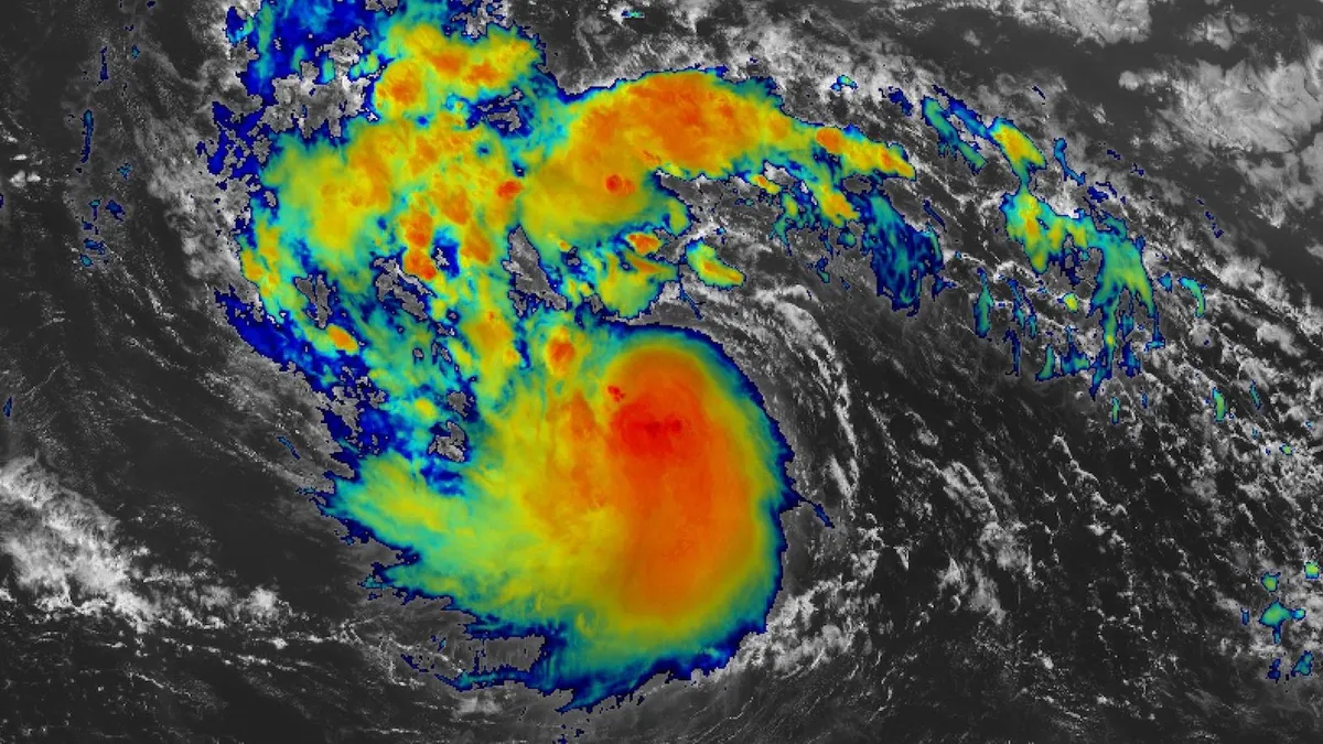
As of Thursday afternoon, a tropical storm watch was issued for the northeast Caribbean islands, including Anguilla, Barbuda, St. Martin, St. Barthelemy, Saba, St. Eustatius, and Sint Maarten, due to the potential for storm-force winds. At 11 a.m. EDT on August 14, Erin was located approximately 900 miles east of the northern Leeward Islands, advancing westward at a speed of 17 mph. The storm's maximum sustained winds increased to 60 mph, rising from 50 mph earlier that day and 45 mph the previous evening. The first reconnaissance flights by hurricane hunters into Erin were anticipated to commence on Thursday night.
By Thursday, Erin's tropical storm force winds were limited to a radius of just 60 miles, but it is expected that the storm's circulation will expand as it continues to strengthen, particularly as it starts to move northward by early next week. A robust cluster of showers and thunderstorms was forming near Erin’s center, with significant convection noted to the north. The National Hurricane Center indicated that Erin is likely to become a hurricane on Friday and continue to intensify through the weekend. This prediction aligns with the latest model guidance from high-resolution systems such as HWRF, HMON, HAFS-A, and HAFS-B.
Several factors are contributing to Erin's strengthening. Although moderate upper-level wind shear is expected to increase over the weekend, it is projected to ease back to light-to-moderate levels of 5-15 mph by early next week. Furthermore, Erin will be situated in a moist air mass, with mid-level relative humidity levels predicted to rise from approximately 55 percent on Thursday to around 65 percent by Monday. The sea surface temperatures in Erin’s path are also expected to increase from about 28 degrees Celsius (82 degrees Fahrenheit) on Thursday to between 29-30°C (84-86°F) starting Sunday, which is 1-2°C (2-4°F) above the mid-August average. Notably, these elevated surface temperatures are up to 100 times more likely due to human-induced climate change, according to the Climate Shift Index from Climate Central.
With these favorable conditions, there is a possibility—albeit not a significant one—that Erin may undergo rapid intensification, characterized by a rise in sustained winds of at least 30 knots (35 mph) within 24 hours. The statistical SHIPS model on Thursday afternoon indicated a 27 percent chance that Erin could gain 55 knots of strength within the next 48 hours, significantly higher than the climatological average. The National Hurricane Center's Thursday morning forecast predicted Erin could reach Category 3 strength (top sustained winds of 115 mph) by Sunday, August 17, and potentially approach Category 4 strength by Tuesday.
Currently, Erin is being directed westward by a strong subtropical ridge of high pressure over the subtropical Atlantic. This ridge is expected to weaken gradually over the next few days, allowing Erin to shift its trajectory more northward. This gradual rightward turn is likely to result in Erin passing just north of the northern Leeward Islands, the Virgin Islands, and Puerto Rico, placing those areas on the weaker side of the storm. Consequently, the Thursday morning forecast indicated a 20-30% chance that sustained winds could reach gale force (39 mph) as Erin approaches this weekend.
The National Weather Service in San Juan, Puerto Rico, has issued warnings for a high risk of rip currents along north- and east-facing beaches. Wave heights are anticipated to reach 8-12 feet across exposed Atlantic waters from Saturday night through Monday. Ensemble models are showing a strong consensus that Erin’s track will likely minimize land impacts. A low-pressure system at upper levels is expected to move into Maritime Canada by early next week, further diminishing the ridge that currently keeps Erin to the south.
Regardless of any potential shifts in Erin’s track, there is high confidence in the threat posed by the storm’s high surf and dangerous rip currents. Coastal areas along the north- and east-facing shores of the Leeward Islands and Greater Antilles will face significant hazards this weekend, which will likely extend to The Bahamas and the U.S. East Coast early next week, eventually affecting coastal regions of Canada.
Meanwhile, convection was expanding in the western Gulf of Mexico and Bay of Campeche due to a northwestward-moving disturbance known as Invest 98L. This weak low may organize sufficiently to become a tropical depression or even a weak tropical storm before making landfall in northeast Mexico or southern Texas by late Friday. Localized rainfall of several inches could occur near the coastline. As of Thursday afternoon, an Air Force reconnaissance mission had not detected any evidence of a low-level circulation.
According to the National Hurricane Center's 2 p.m. Thursday Tropical Weather Outlook, there is a 40 percent chance of this system developing prior to landfall. The next name on the Atlantic storm list is Fernand. This situation bears resemblance to Tropical Storm Barry, which formed off the coast of Veracruz, Mexico, in late June. Barry intensified into a tropical storm shortly before making landfall, resulting in significant flooding in Texas.
In contrast, the current system is expected to move northward after making landfall, with its remnants potentially enhancing showers and thunderstorms over the Central Plains by early next week.