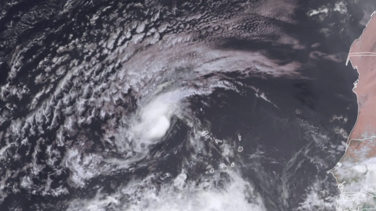
Tropical Storm Erin has embarked on what is anticipated to be a week-long journey across the North Atlantic. Current forecasts suggest that much of this journey will be as a formidable hurricane that warrants close attention. Erin was classified as a tropical storm on Monday after it surged past the Cabo Verde Islands on Sunday as a significant disturbance.
As of 11 a.m. EDT on Monday, Erin was located nearly 300 miles west-northwest of the Cabo Verde Islands, moving westward at a brisk speed of 20 mph. The storm boasted sustained winds of 45 mph. Historical data from 1990 to 2020 indicates that the average formation date for the Atlantic’s fifth tropical storm is August 22, suggesting that the Atlantic is currently experiencing a higher-than-average rate of named-storm production. However, all named systems up to this point have been classified as weak to moderate tropical storms.
The average date for the formation of the first Atlantic hurricane is August 11, and predictive models indicate that Erin could reach hurricane strength by Wednesday, August 13. On Monday, Erin exhibited a small but well-defined circulation, as evidenced by wind data from a satellite-borne scatterometer. Wind shear levels are light to moderate, approximately 10 knots, while the atmosphere remains relatively moist, with mid-level relative humidity hovering around 60 percent. Tropical systems often benefit from nighttime processes that enhance shower and thunderstorm development, a phenomenon known as the nighttime convective maximum, which contributed to Erin’s intensification on Sunday night.
Additionally, Erin benefits from general rising motion across the eastern tropical Atlantic, a result of several large-scale atmospheric features aligning. This alignment provides Erin with a conducive environment for further development.
Geographically, Erin is making an early start. Tropical waves emerging from West Africa are common precursors for Atlantic storm development, although these systems often take several days to organize due to cooler sea surface temperatures (SSTs) in the far eastern Atlantic. On Monday, SSTs beneath Erin were close to the seasonal average, measuring about 26 degrees Celsius (79 degrees Fahrenheit), which is the minimum temperature needed to support the formation of a tropical storm.
Historical analysis from NOAA's Atlantic hurricane database reveals that only 41 tropical storms have developed or traversed within 200 miles of Erin’s initial coordinates (latitude 17.4 north, longitude 28.0 west) over the past 174 years. The most recent of these was Hurricane Margot in 2023, which passed harmlessly across the central North Atlantic. While many of these systems ultimately recurved northward through the Atlantic without affecting the Caribbean or North America, some significant storms have caused extensive damage. For instance, Hurricane Florence (2018) weakened from Category 4 to Category 1 before landfall but still resulted in devastating flooding in North Carolina. Similarly, Hurricane Irma (2017) was the first hurricane on record to strike the northern Leeward Islands at Category 5 strength, eventually causing significant devastation across the Florida Keys and the western Florida peninsula.
Forecast models indicate a strong consensus that Erin will likely intensify into a major hurricane by the weekend and continue to be a significant storm well into the following week. As Erin moves westward over the next few days, it will encounter progressively warmer sea surface temperatures, projected to rise to around 28°C (82°F) by Thursday and possibly reaching 29°C (84°F) by Saturday. Additionally, Erin will approach deeper oceanic heat content as it nears the western North Atlantic early next week, with SSTs about 1°C (2°F) warmer than the mid-August average.
Wind shear is expected to remain light to moderate for the next several days, and the surrounding atmosphere should stay relatively moist. However, wind shear may increase late in the week before moderating again by the weekend, which could temporarily halt Erin's intensification. Currently, Erin is a relatively small system, allowing for rapid changes in strength.
The National Hurricane Center's initial forecast suggests gradual strengthening, with Erin potentially reaching hurricane strength by Wednesday and Category 3 status (major hurricane) by Saturday. As of Monday, multiple ensemble models indicate a higher likelihood that Erin will recurved east of North America rather than making landfall on the U.S. East Coast. This is due to the prediction of an upper-level trough moving across the northeast United States and into the North Atlantic that could influence Erin's path.
Nearly all members of the Sunday-evening and Monday-morning European and GFS model ensembles, alongside the experimental Google AI tropical model ensemble, suggest that Erin may sharply turn north and northeast, potentially impacting Bermuda after making a significant right turn just north of the Leeward Islands. It is crucial to note that any potential recurvature is not expected to begin until a week from now, allowing ample time for steering currents to adjust.
For the time being, the strong agreement among forecast models is a positive indicator, but it remains essential to monitor for any substantial shifts in the models over the coming days. Assuming Erin intensifies into a prolonged hurricane as predicted, it is expected to generate extensive swells, leading to high surf, coastal erosion, and dangerous rip currents along a broad stretch of the North American Atlantic coast, including the north-facing shores of the Greater Antilles islands.
In conclusion, Erin is projected to be the only significant system of concern in the Atlantic for at least the next week. The 2 p.m. Monday Tropical Weather Outlook from the National Hurricane Center noted two weak systems in the central North Atlantic, each with only a 10 percent chance of modest development over the next two days. A disturbance off the central Gulf Coast was assigned near-zero odds, although it could still produce localized rain amounts of 2 to 4 inches in the western Florida panhandle early this week.