A life-threatening winter storm system has begun to unleash devastating flooding rains across Southern California, starting Wednesday and is projected to persist beyond Christmas Day. The severe weather has prompted evacuation orders within the Los Angeles area, impacting millions of residents.
As of early Thursday, over 38 million people were placed under flood watches. In response to the extreme weather conditions, California Governor Gavin Newsom has declared a state of emergency in several Southern California counties. This action comes as a result of threats posed by a series of atmospheric rivers, characterized by intense rainfall and powerful winds, which are exacerbating already saturated soils.
The National Weather Service (NWS) has issued a rare High Risk of Excessive Rainfall warning that will remain in effect through Christmas Day across Southern California, especially in the Los Angeles metropolitan area. These hazardous atmospheric river conditions are expected to persist, causing flash flood warnings across regions including Goffs, San Bernardino County, and LA County's Antelope Valley. Flood watches are also active for the rest of the Los Angeles and San Francisco Bay areas until Friday.
According to the NWS, widespread flash flooding was reported in Southern California as rainfall rates reached between 0.5 to 1 inch per hour. The heaviest rains are expected to hit the LA Basin area on Christmas Eve. Governor Newsom's emergency proclamation emphasizes the urgent risk of flooding, landslides, debris flows, and rapidly rising creeks and rivers, particularly in recently burned areas such as the Airport, Bridge, Line, Palisades, and Eaton Fire burn scars.
The NWS warns that aside from flash and urban flooding, the intense rainfall is likely to trigger dangerous rock and mudslides throughout Southern California. Additionally, widespread power outages and tree damage are anticipated due to the combination of strong wind gusts and saturated soils in the region.
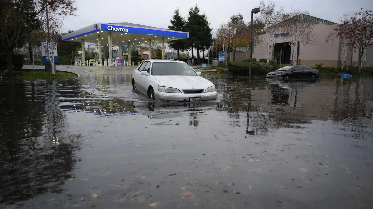
In adjacent areas, including Northern and Central California (the Bay Area) and Southern Nevada (including Las Vegas), scattered instances of flash flooding are also possible through Thursday morning, as reported by the NWS. In the Sierra Nevada mountains, snowfall totals are expected to reach several feet, making travel over passes impossible through the week.
The initial storm has already delivered up to 10 inches of rain in the mountains and around 5 inches in other areas, accompanied by wind gusts reaching 80 mph. As the storm begins to move east of LA County, lingering showers may still occur. While rainfall has largely ceased in Antelope Valley, a FLOOD WARNING remains in effect due to ongoing significant flooding, as reported by the NWS LA.
Heavy rainfall in the San Gabriel Mountains continues to contribute to increased water flow into Antelope Valley. The NWS LA has cautioned that road conditions will deteriorate following Wednesday's intense storm, which caused numerous mud and rockslides and left several inches of water and debris on the roads.
A second storm system is anticipated to produce additional showers and possible thunderstorms throughout Christmas Day. Although the San Francisco Bay area is experiencing a brief respite from the severe weather, the NWS has warned that strong and damaging winds will return overnight and last through Thursday.
Atmospheric rivers are narrow corridors of moisture-laden air that can carry vast amounts of water vapor across great distances. Research indicates that climate change is increasing the moisture content in these systems, resulting in higher rainfall and snowfall totals. The current atmospheric river has subtropical origins, as noted by climate scientist Daniel Swain, and is being further intensified by unusually warm ocean surface temperatures along the California coast.
As we approach the end of December, predictions suggest that this month could be one of the warmest on record for much of the U.S. West.
As Southern California continues to grapple with the impacts of this severe winter storm system, residents are urged to stay informed about evolving weather conditions and to heed evacuation orders where necessary. The combination of excessive rainfall and strong winds poses serious risks, making safety a top priority.