Severe weather conditions and life-threatening flash flooding continue to plague much of the Mid-South and extend up through the Ohio River Valley. As we approach Saturday, this multi-day high-impact flood event is expected to reach its peak, causing significant disruptions across the Lower Mississippi River Valley and the Mid-Mississippi River Valley, which remain under a high-risk category for flooding.
Forecasts indicate that areas could receive an additional 3 to 6 inches of rain from Saturday into Sunday, with some regions potentially seeing even higher amounts. This rainfall is likely to result in catastrophic flooding, particularly in regions already experiencing severe weather. While the threat of severe storms is expected to gradually diminish over the weekend as the stationary front moves eastward, unsettled weather will persist in areas that have already been severely affected by tornadoes and dangerous flooding.
On Saturday, the risk for severe weather extends from eastern Texas all the way to Kentucky, with the Lower Mississippi River Valley facing the highest threat level. Millions of residents are currently under an enhanced risk (level 3 of 5), which indicates the potential for damaging winds, large hail, and multiple tornadoes, some of which could be strong. Cities like Memphis, Tennessee; Shreveport and Lafayette, Louisiana; and Jackson, Mississippi are at the forefront of this severe weather threat, facing the likelihood of intense storms capable of producing strong tornadoes and powerful winds.
Earlier today, parts of the Texarkana region (Miller County in Arkansas and Bowie County in Texas) were placed under a Flash Flood Emergency. A Tornado Watch is currently in effect until 7 p.m. CT for sections of Arkansas, eastern Texas, northern Louisiana, northern Mississippi, and western Tennessee. In addition, a flash flood emergency has been declared for Little Rock, Arkansas, and surrounding areas, including Conway, North Little Rock, and Cabot, as torrential rain continues to sweep across the already saturated ground of central Arkansas.
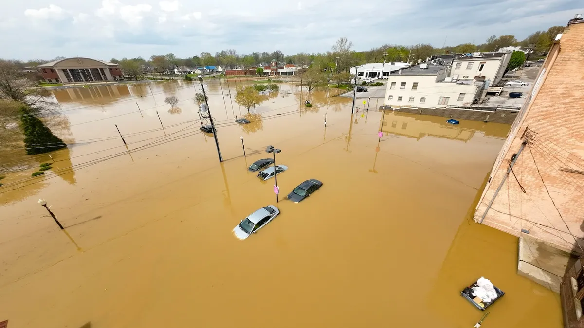
The National Weather Service (NWS) has labeled this a particularly dangerous situation, indicating that life-threatening flash flooding is either ongoing or imminent. A flash flood emergency represents the highest level of alert issued by the NWS for flash flood threats. Emergency management officials have reported multiple water rescues in progress, along with numerous road closures, as reports indicate that between 8 to 12 inches of rain has already fallen in parts of the Little Rock metro area.
Another flash flood emergency has been issued for northeastern Arkansas, affecting towns like Cherokee Village and Hardy. Emergency management has communicated to the NWS that multiple water rescues are taking place in this area, particularly in Lawrence and Sharp counties. While the immediate threat for severe weather and excessive rainfall may ease slightly on Sunday, parts of the Tennessee and Ohio River Valley could still see another 3 to 6 inches of rain before the frontal boundary fully exits the region by Monday.
In the Southeast, areas are currently under a slight risk (level 2 of 5) for severe weather, where storms may produce damaging winds, hail, and isolated tornadoes. Thunderstorms could generate heavy rainfall, with rates potentially reaching 2 to 3 inches per hour, heightening the risk of flash flooding in susceptible areas. Regions in Georgia, Alabama, and parts of the Florida Panhandle, along with southern Mississippi and southeastern Louisiana, are under a slight flood risk.
Following a third night of destructive storms, areas within the mid-Mississippi and Ohio River Valleys are still at risk. A stagnant frontal boundary across the region will lead to further rounds of torrential rain and strong storms on Saturday. Over a dozen tornadoes were reported yesterday across Texas, Arkansas, and Missouri, prompting ongoing flood alerts from Texas to Pennsylvania.
Overnight, flash flood emergencies were declared for Cape Girardeau County and Van Buren in Missouri, with emergency management officials confirming ongoing water rescues. As the weather system continues to evolve, residents are urged to remain vigilant and heed any warnings from local authorities and the National Weather Service.