An intense atmospheric river-fueled storm has made landfall on the West Coast, bringing heavy rain and posing significant risks for mudslides and debris flows in Southern California. The storm, which started early Wednesday, has already triggered evacuation orders in various areas of Los Angeles. As the week progresses, the storm's impacts are expected to escalate dramatically, putting millions at risk of severe weather events including wildfires, blizzards, severe thunderstorms, and tornadoes.
The storm initially soaked the Pacific Northwest before advancing southward, with rain beginning in Northern California prior to sunrise. By the afternoon, soaking rain and mountain snow will blanket Northern California, extending into Southern California later in the evening. This influx of moisture raises the threat of flooding, particularly overnight and into Thursday. A risk level of 2 out of 4 for flooding rainfall has been designated from Santa Barbara to Los Angeles, affecting areas recently burned in the Palisades and Eaton fires, as indicated by the Weather Prediction Center.
To mitigate risks, California Governor Gavin Newsom has mobilized over 400 state personnel to prepare for the storm's effects. Evacuation orders currently apply to about 120 homes considered “vulnerable properties” near burn scars, with additional orders impacting over 1,700 people near the Sierra Madre's Eaton Fire burn scar. Residents in and around these high-risk areas are advised to remain vigilant and prepared to evacuate on short notice. Evacuation warnings have also been issued in parts of San Bernardino County due to the potential for debris flows.
In light of the storm, a segment of the Pacific Coast Highway will close from eastern Malibu to Will Rogers Beach starting at noon Wednesday due to anticipated debris flows and flooding. Heavy snowfall and strong winds are expected to create perilous travel conditions in California's Sierra Nevada by Wednesday night.
As the storm moves eastward, rain and snow will spread across more regions, impacting much of the Rockies by evening. Mountainous areas could see over half a foot of snow, with lower elevations also receiving several inches. By late afternoon, strong winds are forecasted across Nevada, Arizona, and the Rockies, potentially reaching gusts of 40 to 50 mph, creating hazardous travel conditions.
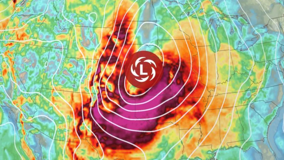
The central U.S. will also experience heightened fire risks as gusty winds emerge, with a level 2 out of 3 fire weather risk issued for over 800 miles stretching from western Texas to Nebraska. Any spark under these conditions could ignite a fast-moving wildfire. Meanwhile, wet weather will persist in California and the Pacific Northwest, with the Sierra Nevada expected to accumulate significant snow, vital for the region's water supply during the dry season.
By Friday, the storm will rapidly intensify as it moves into the Plains, replicating last week’s severe weather patterns. Expect strong winds that may disrupt travel and pose risks to power lines, with gusts reaching 40 to 50 mph by late afternoon. Conditions will be particularly dangerous in eastern New Mexico and the Southern Plains, where increased fire danger is anticipated.
Severe thunderstorms are expected to develop by late afternoon in the Mississippi Valley as the storm's cold front collides with warm, moist air from the Gulf of Mexico. A level 3 out of 5 risk for severe thunderstorms has been issued from Mississippi through much of Illinois, with potential for wind gusts exceeding 75 mph and strong tornadoes, particularly after dark, which substantially increases the risk of fatalities.
The powerful storm will broaden its reach into the eastern U.S. on Saturday, bringing severe thunderstorms and blizzard conditions. Early morning storms may persist, particularly across the Ohio Valley, with new dangerous storms emerging in the afternoon along the Gulf Coast and Southeast. Expect damaging winds, hail, and possible tornadoes, along with heavy rain that could lead to flash flooding from Mississippi to northern Georgia and extending into Kentucky.
As the storm progresses, snow, ice, and strong winds will impact the north-central U.S., creating blizzard conditions that could obstruct visibility significantly, reminiscent of last week's storm that caused widespread disruptions. Fortunately, winds will begin to diminish as the system moves eastward into the weekend.
Sunday is anticipated to bring continued rain and storms across much of the East Coast, with some severe thunderstorms still possible, albeit less intense than those seen earlier in the week. Residents are urged to stay informed and prepared as the storm system continues to evolve.
Stay tuned for further updates on this developing situation as meteorologists monitor the storm’s path and potential impacts.