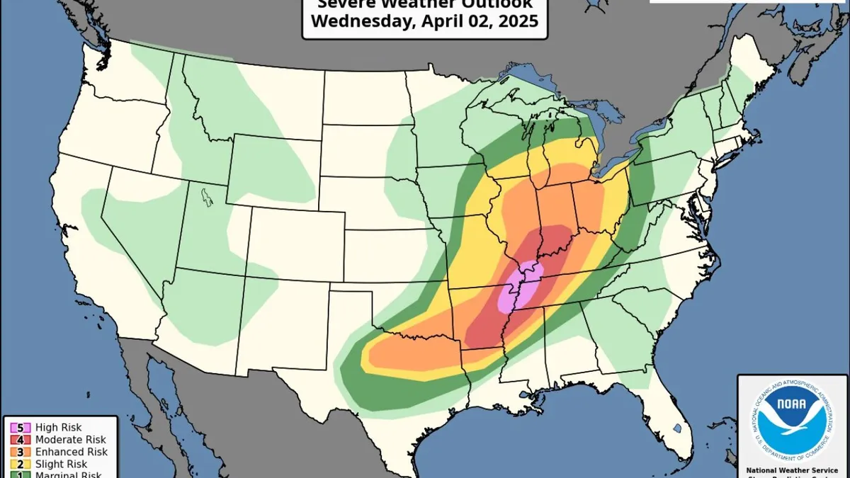
Millions of residents across a vast area of the United States, stretching from Texas to Michigan, are bracing for a significant storm system that is set to bring heavy rain, high winds, hail, flooding, and other dangerous weather conditions starting Wednesday. The National Weather Service (NWS) has issued warnings about this multi-day catastrophic event, which is expected to produce life-threatening conditions, including powerful tornadoes and widespread flash flooding.
An NWS map indicates that cities like Memphis and Little Rock are under high and moderate risks for severe weather, respectively. Other urban areas such as St. Louis, Cincinnati, and Louisville are also likely to experience inclement conditions. Kentucky Governor Andy Beshear has declared a state of emergency in anticipation of the storm, emphasizing that the state is facing some of the most serious weather threats he has witnessed.
In Little Rock, Arkansas, the mayor announced via social media that the city would cancel its weekly test of emergency warning sirens. Residents were informed that any sirens they may hear on Wednesday would signal an imminent tornado. The NWS has identified specific areas most susceptible to tornado formation, which include northeastern Arkansas, western Tennessee, western Kentucky, southern Illinois, and southeastern Missouri. Some of these tornadoes could reach EF3 strength, characterized by wind gusts ranging from 136 to 165 miles per hour.
Outside of the high-risk regions, other parts of the affected states, along with areas in Indiana, Ohio, Mississippi, and Texas, could also experience less severe tornadoes, along with strong wind gusts and hail. NWS forecasters anticipate that intense thunderstorms will strike large areas of the Great Lakes region, Appalachia, and Texas, with some locations potentially recording historic rainfall totals as high as 15 inches through the weekend.
The storm front is expected to stall over the region on Thursday, which could result in up to six inches of rain falling in just two days. Repeated rainfall could saturate the soil significantly and exacerbate flooding conditions. The NWS Memphis office cautioned that this is not a routine weather event, describing it as a rare, high-impact, and potentially devastating situation. People living in the storm's path should be prepared for prolonged disruptions to their daily lives due to the anticipated rainfall and flooding.
As this severe weather system approaches, it is crucial for residents in the affected areas to stay informed through local news outlets and official weather channels. Taking necessary precautions and being prepared for potential evacuations can help ensure safety during this dangerous weather event.