According to the National Hurricane Center, Hurricane Melissa is currently undergoing extreme rapid intensification, having increased its winds by an astonishing 70 mph in just 24 hours. As of now, Melissa has reached Category 4 status and continues to strengthen, with forecasts indicating it may escalate to Category 5 before making a catastrophic, multi-day strike on Jamaica. This severe storm poses life-threatening threats including flash flooding, landslides, destructive winds, and storm surge.
Hurricane Melissa's torrential rains are expected to trigger catastrophic flooding in Haiti, with the storm later impacting eastern Cuba and parts of the Bahamas. Currently, the center of Hurricane Melissa is located just over 100 miles south-southwest of Kingston, Jamaica. The storm is moving at a forward speed of approximately 5 mph, which significantly contributes to its potential hazards.
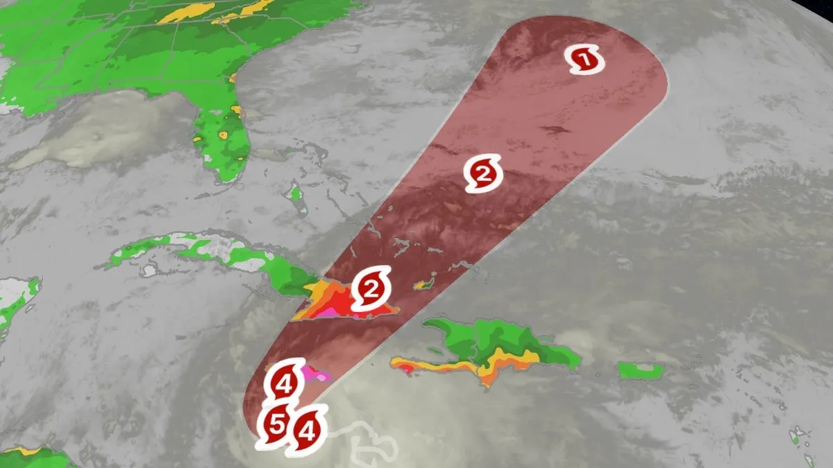
Melissa rapidly intensified from a tropical storm to a Category 3 hurricane within just 12 hours over the weekend. By Sunday morning, it escalated further to Category 4, although it has temporarily leveled off in intensity. Meteorologists anticipate that Melissa will strengthen once again on Monday.
Outer bands of showers and thundershowers, accompanied by heavy rainfall, continue to sweep across parts of Jamaica, Hispaniola, and Cuba. A wind gust of 46 mph was recorded in Kingston on Sunday afternoon, indicating the storm's growing strength.
One of the most alarming aspects of Hurricane Melissa is its slow movement, which is expected to lead to significant rainfall over the coming days. The National Hurricane Center warns that southern Hispaniola and Jamaica could receive up to 40 inches of rain by Wednesday. This torrential precipitation is likely to cause widespread, life-threatening flash flooding and landslides, particularly in hilly and mountainous areas.
The potential for extensive infrastructural damage, long-duration power and communication outages, and prolonged isolation of communities is high in both Jamaica and Haiti. Heavy rainfall is also predicted to trigger flash flooding and landslides in the Dominican Republic and eastern Cuba.
In addition to the rainfall and flooding threat, the NHC has issued storm surge warnings indicating a surge of 9 to 13 feet above ground level to the east of where Melissa is projected to make landfall along Jamaica's southern coast early Tuesday. This surge could impact parts of Kingston, including the Norman Manley International Airport, as highlighted by Yale Climate Connections expert Jeff Masters.
Hurricane Melissa is expected to drift slowly westward through early Monday before curling northeast and increasing its forward speed. This trajectory is likely to bring the storm's core over central or western Jamaica on Tuesday, followed by a movement into eastern Cuba Tuesday night or early Wednesday, and then quickly through the southeast Bahamas or the Turks and Caicos Islands on Wednesday. It remains uncertain whether Melissa will pose a threat to Bermuda later in the week.
Melissa is projected to peak at Category 5 intensity and may maintain at least Category 4 intensity at landfall in Jamaica, benefiting from the warm, deep waters of the Caribbean Sea. Notably, although eight other Category 4 or 5 hurricanes have passed within 60 nautical miles of Jamaica, there is no record of such an intense storm making landfall there, which makes this event potentially historic.
According to the National Hurricane Center, hurricane conditions in Jamaica are expected to begin later on Monday, with possible impacts in eastern Cuba from Tuesday into Wednesday. Tropical storm conditions are already being experienced on the island and may persist for several days. Currently, a hurricane warning is in effect, indicating that hurricane-force winds are expected, while tropical-storm-force winds may linger for more than a day.
The tropical storm warning indicates that conditions are expected to deteriorate by Tuesday in Haiti and Cuba. These alerts encompass parts of southern Haiti, Jamaica, and eastern Cuba, with the NHC warning that these conditions, combined with flash flooding, could lead to severe infrastructural damage and prolonged isolation of communities.
Hurricane Melissa formed late Tuesday morning, marking it as the 13th storm of the 2025 Atlantic hurricane season. By Saturday afternoon, it had developed into the season's fifth hurricane, aligning closely with the average date for the 13th storm from 1991 through 2020 (October 25). This storm is notable as it is the first of the season to venture into the Caribbean Sea. The majority of other storms this season have veered north of the Caribbean due to steering winds in the Atlantic or unfavorable conditions for development in the region prior to Melissa.
For the latest updates and forecasts on Hurricane Melissa and other tropical activities, check back with us at weather.com.