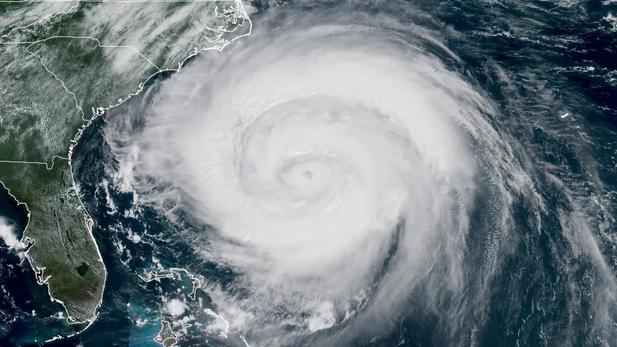
Tropical storm warnings are currently in effect for parts of the North Carolina and Virginia coast as Hurricane Erin moves northward, set for a close pass near the Outer Banks of North Carolina on Thursday. As of 2 p.m. EDT on Wednesday, Hurricane Erin was located approximately 335 miles (540 km) south-southeast of Cape Hatteras, North Carolina, traveling north at a speed of 13 mph (20 km/h). Satellite imagery indicates that Erin is intensifying, showcasing a distinct eye surrounded by a vast area of intense thunderstorms characterized by cold cloud tops.
Hurricane Erin has seen its top sustained winds increase to 110 mph (175 km/h), with the central pressure dropping to 943 mb. According to meteorologist Michael Lowry, this central pressure is notably low for a storm of this intensity. In the historical satellite record, only a few hurricanes—Maria (2017), Irma (2017), Sandy (2012), Igor (2010), and Gloria (1985)—have recorded similar low pressures while maintaining winds below the Category 3 threshold of 115 mph.
As Hurricane Erin approaches, it is forecasted to pass about 250 miles (400 km) off the coast of North Carolina on Thursday. However, tropical storm conditions and coastal flooding are anticipated to begin impacting the Outer Banks by this evening. The hurricane's large size has resulted in hurricane-force winds extending up to 105 miles from its center and tropical storm-force winds reaching 265 miles. This expansive wind field has generated significant wave activity affecting the east coast of North America, including the Bahamas and Bermuda.
These waves pose a serious risk for coastal erosion and dangerous rip currents. Along the North Carolina coast, waves are expected to combine with a storm surge of two to four feet, leading to damaging coastal flooding. The National Oceanic and Atmospheric Administration (NOAA) has predicted that Erin's storm surge will result in major flooding at three tide gauges during Thursday evening's high tide along the northern North Carolina coast and into Chesapeake Bay in Virginia.
The most significant marine impacts are likely to occur in the Outer Banks, where waves could reach heights of 10-20 feet, exacerbating the storm surge. Vulnerable coastal homes may face severe damage or destruction due to multiple cycles of high surf, which can also lead to road closures and widespread beach erosion. While extensive heavy rainfall is not expected, sustained winds may exceed tropical-storm-force (39 mph), accompanied by notably higher gusts.
Current predictions indicate that Hurricane Erin will continue to experience favorable conditions for intensification until Thursday. However, increasing wind shear is expected to trigger a slow weakening trend. Factors such as ocean temperatures and dry air will begin to influence Erin, leading to its anticipated transformation into an extratropical cyclone by Sunday as it curves northeastward out to sea, just south of Newfoundland, Canada.
In addition to Hurricane Erin, meteorologists are keeping an eye on two tropical waves. The first wave, located in the central Atlantic, is moving westward at about 20 mph (32 km/h) and is expected to approach the vicinity of the Leeward Islands on Friday. This wave is currently broad and disorganized, hampered by dry air from the Saharan Air Layer. Limited model support exists for the development of this disturbance over the next few days, though there is increased support for potential development by Saturday or Sunday. According to the National Hurricane Center (NHC), the odds of formation over two days and seven days stand at 10% and 60%, respectively, with the next name on the Atlantic storm list being Fernand.
The second tropical wave is located in the far eastern Atlantic, just southwest of the Cabo Verde Islands, moving westward at approximately 15 mph (24 km/h). Designated as 99L by the NHC, this system is experiencing moderately favorable conditions for development, with sea surface temperatures around 28 degrees Celsius (82°F) and moderate wind shear. However, a large area of dry air to the north is likely to impede its development in the coming days. The NHC has issued formation odds of 40% for 99L over the next two days and seven days.