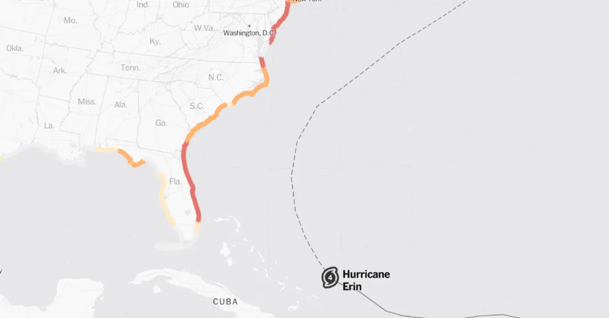
Hurricane Erin is rapidly expanding in size, and its potential impact is expected to extend far beyond its immediate vicinity. Almost the entire East Coast of the United States is currently at risk for perilous rip currents. In response to this escalating threat, officials in North Carolina have ordered the evacuation of certain coastal areas, worried that the storm's outer bands could bring heavy rains and intense winds as early as Wednesday.
As of Monday, the hurricane's eye measured over 35 miles in diameter, with tropical-storm-force winds (defined as winds of 39 miles per hour or higher) extending an astonishing 230 miles from the center. Generally, hurricanes exhibit tropical-force winds that reach about 150 miles outward; however, Erin's wind field is nearly double that and continues to grow, as noted by the National Hurricane Center.
Despite being located far from shore, the storm's edges may still affect parts of the Carolinas, prompting concerns about rip currents and beach hazards that could impact areas along the East Coast from Florida to Canada. Although the storm is projected to generally pass through open waters between Bermuda and the East Coast, recent forecasts have slightly adjusted its expected path westward, raising new concerns about its potential impact.
In light of the approaching storm, authorities in Hyde County, North Carolina, declared a state of emergency for Ocracoke Island on Sunday night, mandating evacuations. Officials indicated that while Hurricane Erin is likely to remain offshore, it could still generate hazardous waves exceeding 20 feet, which may threaten protective dune structures along the highway. As a result, parts of Highway 12 on Ocracoke Island are anticipated to be impassable for several days. On Monday, hundreds of tourists were seen leaving this small coastal community, which is accessible only by boat and typically crowded during the summer months.
Meteorologists and the computer models they utilize have shown confidence that the storm will curve away from the East Coast by mid-week. However, any further shifts to the west could expose the North Carolina coast, particularly the Outer Banks, to more severe conditions, including tropical storm-like weather and potentially hurricane-force wind gusts. Forecasters at the National Hurricane Center cautioned that "interests along the Outer Banks and Bermuda should monitor the progress of Erin," as the outer rain bands may pose risks of strong winds.
North Carolina's position jutting into the Atlantic makes it vulnerable to hurricanes like Erin. Over the years, the Outer Banks have faced significant damage from rising sea levels and large storm swells. Forecasters from the National Weather Service on the Outer Banks expressed increased confidence in the potential for hazardous conditions due to the storm.
As the storm generates a large swell, energy will pulse toward the East Coast, creating rip currents. These currents often occur in seemingly calm areas of the beach and can be particularly dangerous, even in shallow water. Rip currents are known to be the third-highest cause of hurricane-related fatalities. Historical data shows that storms like Hurricane Bertha, which was over 1,000 miles offshore in 2008, still generated rip currents that resulted in three deaths along the New Jersey coast and necessitated 1,500 lifeguard rescues in Ocean City, Maryland, within a single week.
Warnings regarding the increased risk of rip currents have already been issued for the entire East Coast of the United States for the coming days. When hurricanes are closer to shore, beachgoers often encounter lightning, rain, and rough seas, which serve as clear indicators of danger. However, when storms are farther away, conditions may appear deceptively safe, with sunny skies and calm waters masking the potential hazards present. Experts advise swimming only in areas supervised by lifeguards and paying attention to beach warning flags to ensure safety.