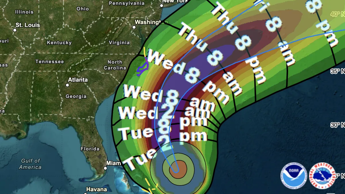
Hurricane Erin is steadily moving closer to the Eastern seaboard, bringing with it a host of dangers, including perilous rip currents and significant flood risks. As a result, evacuation orders and states of emergency have been issued in two counties in North Carolina. As of 11 a.m. ET on Tuesday, the National Hurricane Center reported that Hurricane Erin was located 690 miles south-southeast of Cape Hatteras, North Carolina. The storm is currently moving northwest at a speed of 9 mph and is packing maximum sustained winds of 105 mph. This marks a notable decrease from Monday’s peak winds of 140 mph, but meteorologists expect the storm to regain strength and increase in size.
While Hurricane Erin is not anticipated to make landfall in the United States, forecasters warn that it will generate large waves ranging from 15 to 20 feet or higher along the shoreline, accompanied by dangerous storm surges. A tropical storm warning is currently in effect for the Outer Banks, specifically from Beaufort Inlet to Duck, indicating that tropical storm conditions are expected within the next 36 hours. Additionally, a storm surge warning has been issued for the Outer Banks, extending from Cape Lookout to Duck. National Hurricane Center Director Michael Brennan emphasized the seriousness of the situation, stating, "there's a danger of life-threatening inundation of 2 to 4 feet above ground level."
Mandatory evacuation orders have been enacted for residents on Hatteras and Ocracoke islands within the Outer Banks. Authorities are urging individuals to evacuate before seawater overtakes Highway 12, the primary roadway linking numerous communities in North Carolina. Drew Pearson, the Emergency Management Director for Dare County, issued a stern warning, urging all residents and visitors to heed the evacuation orders: "Take action to protect yourselves and your property — leave now." Once the water arrives, officials from the National Weather Service in Morehead City, North Carolina, have warned that roads and vehicles in low-lying areas could be submerged for days.
The National Hurricane Center has identified a high risk of life-threatening surf and rip currents from Florida up to Long Island, New York. Anyone planning to visit East Coast beaches this week is strongly advised to consult local or national maps indicating rip current risks. The latest forecasts indicate a westward shift in Erin’s predicted track, raising the likelihood of impacts along the coast. Although the storm's wind speeds have diminished from nearly 160 mph over the weekend, the hurricane center warns that Erin's massive size remains a significant threat.
Erik Heden, the warning coordination meteorologist at the National Weather Service, clarified the misconception regarding storm impacts: "Even though the center of the storm is well out to sea, it's hundreds of miles across." Erin is projecting tropical-storm-force winds up to 205 miles from its center, with hurricane-force winds extending up to 80 miles. Due to the storm's unusual size, the Hurricane Center cautions that even its advisories may underestimate the risk of tropical-storm-force winds reaching the shore this week, affecting areas from North Carolina to southern New England.
While wind speed often dominates headlines, the size of a hurricane is crucial in assessing potential damage and risk. Matthew Janssen, a research assistant professor and engineer specializing in coastal hazards at the Stevens Institute of Technology, explains: "The size of the storm is correlated with higher storm surge levels over larger areas, leading to more significant impacts." The Outer Banks, which extend for miles from the mainland, are particularly vulnerable to being washed out, with some areas of the barrier islands measuring only a thousand feet wide.
Despite the potential dangers, there is a silver lining in the forecast; Erin is expected to approach the coast without making a direct hit. This means that while coastal communities will experience severe conditions, areas further inland are likely to face less severe weather. However, both Heden and Janssen agree that the storm's imposing waves could reshape beaches, wash over dunes, and erode coastal landscapes.
Hurricane Erin marks the first hurricane of the Atlantic season, which commenced in June. Experts caution against drawing conclusions from the relatively slow start to the season. The prevailing consensus among meteorologists is that climate change may lead to fewer hurricanes overall, but those that do form are likely to be more intense, particularly major storms categorized as Category 3 or higher. In this context, Erin exemplifies the evolving patterns of hurricane behavior in our changing climate.