At least one person has died as a powerful storm wreaks havoc on the eastern United States, bringing with it dangerous flooding and prompting hurried evacuations, widespread road closures, and hazardous travel conditions across several states.
A 73-year-old resident of Manchester, Kentucky, lost his life in the Horse Creek area after being swept away by heavy floodwaters upon exiting his vehicle Saturday night, according to the Clay County Coroner’s Office.
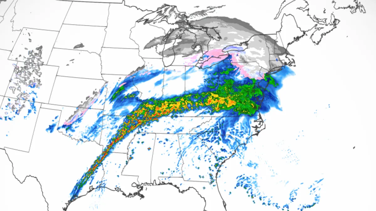
Flash flood emergencies and warnings were in effect for hundreds of thousands across West Virginia, Virginia, Kentucky, Arkansas, and Tennessee through Saturday night. In Virginia alone, over 413,000 individuals were under a flood threat capable of causing “considerable damage.”
Numerous tornado warnings were issued in Mississippi, West Tennessee, and Southeast Arkansas on Saturday evening, with a significant tornado watch extending over much of Mississippi and Alabama for the overnight hours.
As of Saturday evening, more than 19,000 homes and businesses in Virginia were without power, according to poweroutage.us. Additionally, over 16,000 residents across Kentucky and Louisiana were left in the dark.
Heavy rains have pummeled parts of Virginia, with flash floods reported in the southwest region. Governor Glenn Youngkin urged residents to stay alert and avoid fighting the water, emphasizing the importance of seeking safety and assistance if necessary.
In Kentucky, widespread flooding has led to road closures, landslides, and evacuations, with some areas experiencing historic water levels. Governor Andy Beshear declared a state of emergency, urging residents to take the situation seriously and be prepared to seek higher ground.
Beshear emphasized safety, opening shelters for evacuees and conducting wellness checks through the Kentucky State Police.
Floodwaters have inundated streets and parks, turning them into lakes, and are expected to continue rising. In Bowling Green, Kentucky, the storm sewer system is at maximum capacity, prompting officials to advise residents to stay off the roads.
In Knott County, Danny Laferty expressed concerns about potentially "losing everything again" following previous catastrophic flooding that nearly leveled parts of the state.
The storm, which has already caused significant damage in California, is now battering the eastern US with flooding rain, severe thunderstorms, possible tornadoes, and snow. The storm is expected to reach peak intensity overnight into Sunday before tapering off on Monday, with lake-effect snow potentially impacting parts of the Great Lakes.
Over 1,200 miles from the Gulf Coast to the Northeast could experience flooding, with more than two inches of rain expected in many areas. A rare level 4 of 4 high risk of flooding rainfall is in effect for more than 1.5 million people in parts of northwestern Tennessee and western Kentucky.
Severe thunderstorms are expected to develop south of the heaviest rain, with a significant risk of damaging winds and tornadoes, particularly in Mississippi, where strong EF2 or higher tornadoes could occur.
Nighttime tornadoes are a particular concern due to their increased likelihood of being deadly, especially if they occur after dark when visibility is reduced.
The storm is also bringing snow and ice to its northern side, affecting the Great Lakes and Northeast regions. Snow is expected to transition to a mix of sleet and freezing rain, creating hazardous travel conditions.
Strong winds may lead to power outages in areas affected by snow and ice, with snow totals potentially reaching double digits in parts of the Great Lakes, northern New York, and northern New England.
As the storm moves out, another round of frigid air is expected to spill into much of the US, with temperatures plunging more than 30 degrees below normal in some areas early next week.