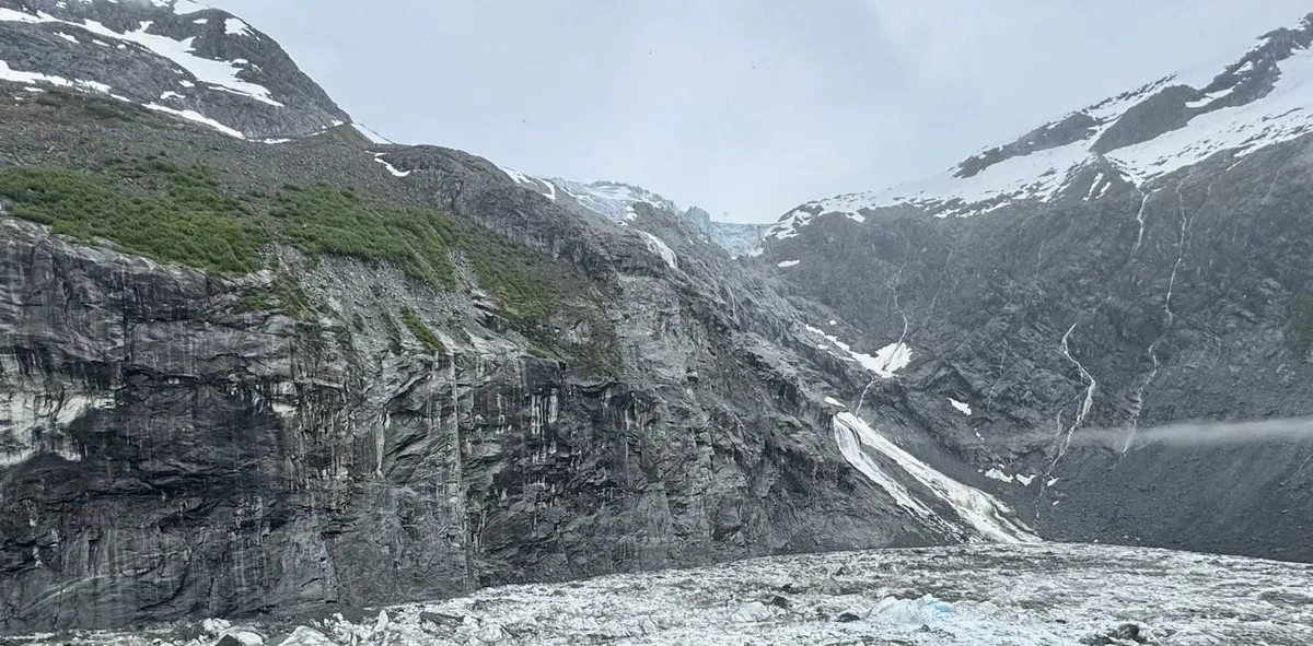
Each summer, the majestic mountains above Juneau, Alaska, witness the flow of meltwater from the expansive Mendenhall Glacier into nearby mountain lakes and the Mendenhall River, which runs through the heart of the town. Since 2011, scientists and local officials have been closely monitoring a specific lake known as Suicide Basin, an ice-dammed depression formed by the retreat of glacier ice in recent decades. During the summers of 2023 and 2024, an alarming situation unfolded as meltwater filled Suicide Basin to overflowing, breaching its rim and escaping through ice tunnels. This led to significant surges of water downstream, resulting in flooding in neighborhoods along the river. The situation escalated on August 12-13, 2025, when another flood from the basin reached record levels at Mendenhall Lake, prompting officials to urge evacuations in vulnerable neighborhoods.
The increasing frequency of these glacial floods poses a serious challenge for communities like Juneau, as similar threats are emerging worldwide. As an Earth scientist and mountain geographer, I study how the loss of ice impacts the stability of surrounding mountain slopes and glacial lakes. The risks associated with glacial floods are becoming more pronounced as global temperatures continue to rise.
Across many mountain ranges, glaciers are melting at an alarming rate. For instance, Europe’s Alps and Pyrenees have lost approximately 40% of their glacier volume from 2000 to 2023. Glaciers have historically provided vital freshwater resources for nearly 2 billion people. However, the rapid melting of these glaciers introduces significant hazards. As ice melts, it often drains into depressions previously occupied by glaciers, forming large lakes that are precariously held by ice dams or rock moraines. Excessive water buildup behind these natural barriers or disturbances like landslides can lead to catastrophic dam failures, unleashing torrents of water and debris down mountain valleys.
The phenomenon of glacial flooding known as jökulhlaup, or “glacier leap” floods, is characterized by the rapid release of water held back by glacial ice. First documented in Iceland, these floods are now common in areas like Alaska. Many glacial lakes began forming over a century ago due to warming trends, but their prevalence and growth rate have accelerated since the 1960s. Communities in the Himalayas, Andes, Alps, Rocky Mountains, Iceland, and Alaska have all faced various forms of glacial lake outburst floods. For example, a significant flood in the Sikkim Himalayas in October 2023 resulted in extensive infrastructure damage and claimed over 50 lives, showcasing the potential devastation of these events.
Avalanches, rockfalls, and slope failures are common triggers of glacial lake outburst floods, with these occurrences becoming more frequent as thawing permafrost destabilizes mountain landscapes. Such slides can generate massive waves that lead to the rupture of ice dams or moraines, unleashing floods that can travel downstream at speeds of 20-60 mph (30-100 kph), wreaking havoc on communities in their path. Historical events, such as the 1941 flood caused by an avalanche into Laguna Palcacocha in Peru, resulted in the destruction of one-third of Huaraz and thousands of fatalities, emphasizing the dire consequences of these floods.
In response to the growing threat of glacial floods, governments around the world have implemented early warning systems and programs aimed at identifying potentially hazardous glacial lakes. In Juneau, the U.S. Geological Survey actively monitors Suicide Basin as it fills. Some regions have resorted to lowering water levels in lakes or constructing flood diversion structures, such as gabions, to protect villages and infrastructure. Additionally, zoning regulations that prohibit construction in flood-prone areas have been encouraged to minimize risk. While public education initiatives have raised awareness about flood risks, the potential for disasters remains high.
While glacial lake outburst floods often dominate discussions, they are not the only flood risks associated with glaciers. Englacial conduit floods can occur when meltwater collects inside expansive systems of ice caves, leading to catastrophic surges of water. Thawing mountain permafrost, which has historically stabilized these environments, is now increasingly implicated in glacial lake outburst floods. As permafrost thaws, the stability of the terrain is compromised, making it susceptible to landslides and other triggering events that can unleash destructive debris flows.
Recent studies indicate that there are over 110,000 glacial lakes worldwide, placing approximately 10 million people at risk from glacial lake outburst floods. To protect communities, several key strategies have emerged from research efforts:
Early Warning Systems: Effective systems, particularly those utilizing cellphone alerts combined with real-time monitoring apps, can empower residents to assess and respond to potential dangers. Proactive Measures: Draining small, emerging glacial lakes before they become large threats can be more effective than attempting to manage larger lakes later. Reliable Information Sources: Remote communities require dependable information channels that provide regular updates and monitoring technology to remain informed about flood risks.With the U.N. declaring 2025 as the International Year of Glaciers’ Preservation, the coming decade will focus on advancing cryospheric sciences. Scientists worldwide will collaborate to better understand the risks posed by glacial floods and to develop strategies that can protect vulnerable communities.