The NISAR (NASA-ISRO Synthetic Aperture Radar) Earth-observing radar satellite has recently transmitted its first images of our planet's surface, marking a significant milestone as the joint mission between NASA and the Indian Space Research Organisation (ISRO) approaches full science operations later this year. Acting NASA Administrator Sean Duffy highlighted the importance of this achievement, stating, “Launched under President Trump in conjunction with India, NISAR’s first images are a testament to what can be achieved when we unite around a shared vision of innovation and discovery.”
As the NISAR mission progresses, NASA aims to build upon the incredible scientific advancements of the past and present, striving to maintain the nation's space dominance through what they term "Gold Standard Science." These first images underscore the high level of detail with which NISAR scans Earth, providing unique, actionable data to decision-makers in areas such as disaster response, infrastructure monitoring, and agricultural management.
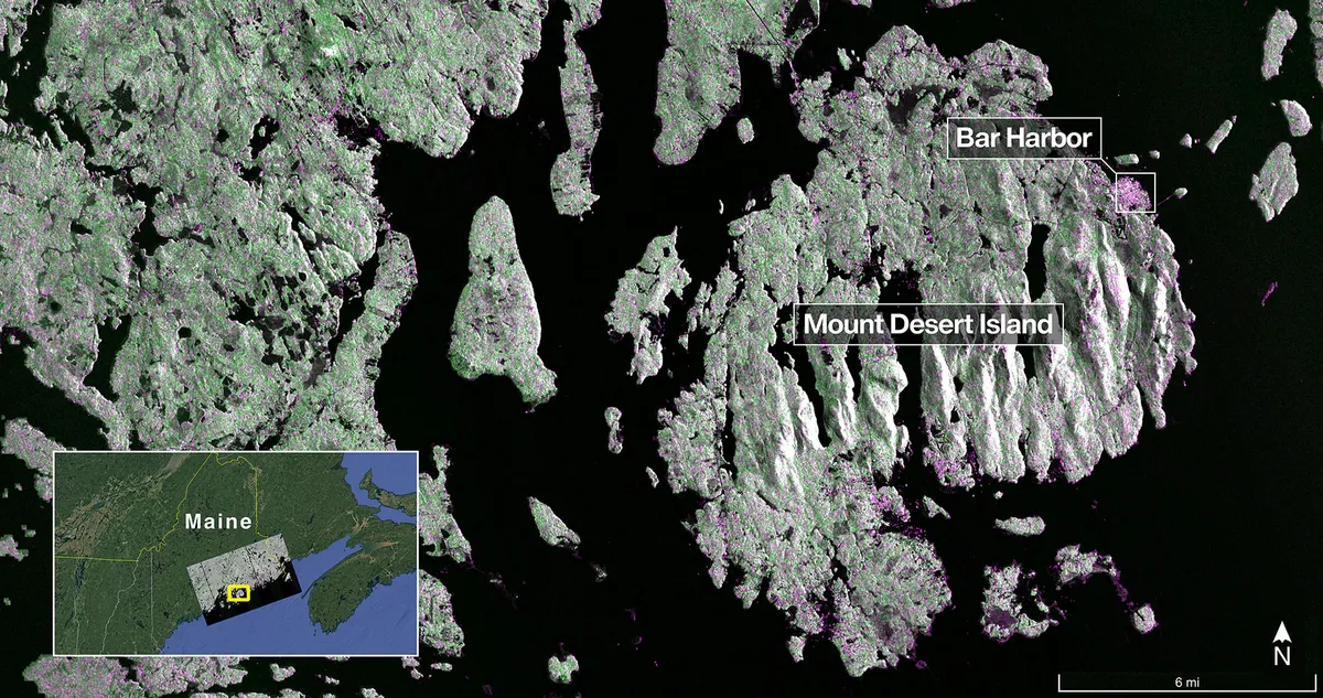
On August 21, the satellite’s L-band synthetic aperture radar (SAR) system, developed by NASA’s Jet Propulsion Laboratory in Southern California, captured an image of Mount Desert Island along the Maine coast. In this image, dark areas represent water, green areas indicate forests, and magenta highlights hard surfaces like bare ground and buildings. The L-band radar's capability to resolve objects as small as 15 feet (5 meters) allowed for the depiction of narrow waterways and the islets surrounding the island.
Following this, on August 23, the L-band SAR captured data from northeastern North Dakota, specifically around Grand Forks and Walsh counties. This image showcases a mixture of forests and wetlands along the banks of the Forest River, along with farmland to the north and south. Dark patches represent fallow fields, while lighter hues indicate the presence of crops such as soybean and corn. Circular patterns in the image reveal the use of center-pivot irrigation, showcasing how the L-band SAR can differentiate between various types of land cover.
These initial images represent just a glimpse of the groundbreaking science that NISAR will deliver. According to Nicky Fox, associate administrator for the Science Mission Directorate at NASA Headquarters, the data and insights generated will enable scientists to study Earth's changing land and ice surfaces in unprecedented detail. Furthermore, this information will assist decision-makers in responding effectively to natural disasters and other significant challenges.
The L-band radar system utilizes a 10-inch (25-centimeter) wavelength that penetrates forest canopies, measuring soil moisture and assessing the movement of ice surfaces and land with remarkable precision. This capability is crucial for understanding land surface dynamics, particularly before, during, and after events such as earthquakes, volcanic eruptions, and landslides.
The initial L-band images serve as a preview of what the mission team will produce when the science phase commences in November. The satellite was successfully placed into its operational orbit of 464 miles (747 kilometers) in mid-September. The NISAR mission also includes an S-band radar, provided by ISRO’s Space Applications Centre, which employs a 4-inch (10-centimeter) microwave signal sensitive to smaller vegetation, enhancing its effectiveness in monitoring certain agricultural and grassland ecosystems.
Notably, NISAR is the first satellite to carry both L- and S-band radars, allowing it to monitor Earth’s land and ice surfaces twice every 12 days. The spacecraft is equipped with a drum-shaped antenna reflector measuring 39 feet (12 meters) wide—the largest ever deployed by NASA in space.
The NISAR mission exemplifies a strong partnership between NASA and ISRO, built on years of technical and programmatic collaboration. The successful launch and deployment of NISAR enhance the long-standing cooperation between the United States and India in the field of space exploration. Key components of the mission, including the S-band SAR provided by the Space Applications Centre, the spacecraft bus from the U R Rao Satellite Centre, and the launch vehicle from the Vikram Sarabhai Space Centre, highlight this collaborative spirit.
Operations such as the deployment of the boom and radar antenna reflector are now being managed by ISRO’s global system of ground stations. NASA’s Jet Propulsion Laboratory leads the U.S. component of the project, which also includes the high-rate communication subsystem for science data and a solid-state data recorder.
For more information about the NISAR mission and its groundbreaking work in Earth observation, visit NISAR's official website.