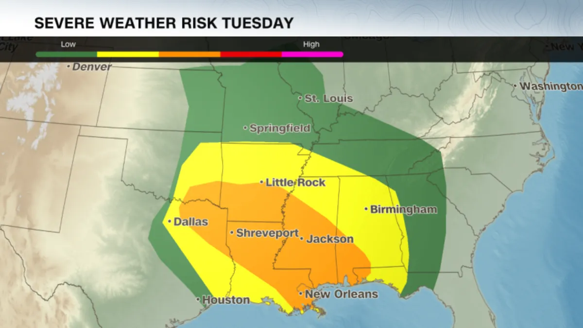
More than 55 million people across the central and southern United States are facing a significant risk of severe weather on Tuesday as a violent storm system sweeps through the region. This storm brings the potential for blizzard conditions, tornadoes, and heightened fire weather risks. This weather event is particularly concerning as it marks the first major storm after the recent staffing cuts at the National Oceanic and Atmospheric Administration (NOAA) and its National Weather Service, a reduction that scientists argue could endanger public safety.
Last week, approximately 800 employees were laid off from NOAA, raising alarms about the ability to effectively monitor and respond to severe weather events. Experts warn that these cuts could have dire consequences for the safety of the American public, especially during periods of extreme weather.
The storm coincides with ongoing Mardi Gras celebrations across the South, notably in New Orleans, where officials are scrambling to adjust event schedules. To mitigate the impact of the impending severe weather, officials have shortened parade routes and rescheduled festivities. The Associated Press reports that a high wind warning has been issued for New Orleans, effective from 9 a.m. to 9 p.m. local time on Tuesday, with sustained winds expected between 20 to 30 mph and gusts potentially exceeding 50 mph.
A tornado watch has been issued for regions in Texas and Oklahoma until 5 a.m. local time Tuesday, affecting nearly 3 million people. As the storm progresses, winds may reach up to 70 mph and hail could fall with diameters of up to 1.5 inches. By late Tuesday morning, the storm is expected to intensify, posing a threat to the Lower Mississippi River Valley with strong tornadoes, heavy rainfall, and large hail.
The most severe weather is anticipated in northern Louisiana, central Mississippi, and southern Arkansas, where cities like Shreveport and Jackson could see particularly dangerous conditions, including wind gusts exceeding 74 mph and significant rainfall of up to 3 inches.
With weather conditions worsening, New Orleans officials are closely monitoring the situation. Police have adjusted parade times and routes to ensure the safety of participants. The National Weather Service has cautioned that Mardi Gras floats could become unstable in the face of the strong winds. Although two of the city's largest parades, organized by the Krewe of Zulu and the Krewe of Rex, were still scheduled for Tuesday morning, police have set a strict end time of 11:30 a.m. for all festivities.
New Orleans Police Superintendent Anne Kirkpatrick emphasized the city's commitment to safety, stating, “I hold that trump card in which I will not hesitate to cancel — I won’t do it lightly, but I will do it.” Meanwhile, Jefferson Parish has already canceled at least two parades due to the anticipated high winds.
In contrast, the central United States is facing a different threat from this strong March storm as snow begins to blanket the Rocky Mountains. The Denver Metro area has already experienced a mix of rain and snow, with blizzard warnings issued for parts of Colorado’s Elbert and Douglas counties above 6,000 feet. Snowfall totals are projected to reach a foot in some locations, along with wind gusts up to 65 mph, which could lead to low visibility and hazardous travel conditions.
Meanwhile, the Southwest is grappling with a massive dust storm that swept across New Mexico, Texas, and parts of Mexico. This phenomenon, known as a haboob, has caused near-zero visibility on roadways, prompting officials to close sections of Interstate 10. Eyewitness accounts describe chaotic scenes as vehicles were caught in the dust storm.
This dust storm is also exacerbating fire weather conditions in the Southern Plains, where more than 8 million people are under red flag warnings due to strong winds and ongoing drought conditions. The National Weather Service has flagged areas in central and southwestern Texas as having an "extremely critical" fire threat, with gusts reaching up to 60 mph and humidity levels dropping to single digits.
As the storm continues to unfold, residents across the affected regions are urged to stay informed and take necessary precautions to ensure their safety during this severe weather event.