A massive storm system is wreaking havoc across much of the United States, bringing with it a mix of dangerous weather conditions including high winds, wildfires, dust storms, and even the potential for blizzards. As the storm advanced eastward overnight, the sky over Dallas transformed to resemble a Martian landscape on Tuesday afternoon, with winds stirring up red dust and igniting fires throughout the dry regions of Texas. The National Weather Service offices in San Antonio and Austin reported at least 15 fire incidents attributed to this severe weather event.
This powerful storm is being fueled by a near-record low pressure system situated in the Midwest, resulting in strong winds sweeping across the Plains and extending to the Southeast. Tragically, at least two fatalities have been reported in Madison County, Mississippi, where storms caused one individual to be electrocuted and another to lose their life when a tree fell onto their vehicle.
The storm is expected to reach the East Coast by Wednesday, bringing a range of potential impacts from Florida all the way to New York. The most intense storms, with the capacity to produce damaging winds and tornadoes, are forecasted to affect areas from Charleston, South Carolina, up through southern Virginia.
As the storm progresses, a line of damaging storms is pushing through Alabama, Georgia, and the Florida Panhandle, posing a threat of strong winds and possible tornado activity. The severe weather threat is expected to stretch from northern Florida to Pennsylvania.
By Wednesday afternoon, the Carolinas and the Mid-Atlantic region braced for the storm's full impact, anticipating strong winds and severe thunderstorms. Lower storm warnings are currently in effect from Florida to southern New York, where residents may experience gusty winds, rainfall, and hail.
In Texas, dozens of fires have ignited due to the critical fire risk affecting much of the state. High winds in Atascosa County have resulted in several house fires, according to local law enforcement. The Texas A&M Forest Service is actively monitoring ongoing fires in Blanco and Duval counties and is responding to requests for assistance.
Meanwhile, strong winds are expected to persist across the Midwest, potentially leading to blizzard conditions in populated areas such as Kansas City, Omaha, and Des Moines. Wind gusts in some locations are projected to reach between 50 to 70 mph.
The severe thunderstorms have already caused widespread power outages, leaving over 400,000 homes and businesses without electricity across the central U.S., Southeast, and parts of the Midwest by late Tuesday, according to PowerOutage.us.
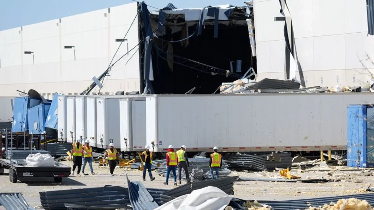
As the storm continues to develop, significant damage has been reported in Texas and Oklahoma. In the Dallas-Fort Worth area, severe thunderstorms have resulted in hazardous conditions and damage to buildings, including a paint storage facility in Lewisville, which suffered damage before employees arrived. Nearby Irving has also reported significant storm-related damage, including downed power lines.
In Williamson County, north of Austin, at least eight fires have been documented, with most being contained by first responders. A grass fire in San Antonio led to the evacuation of about 30 households as local officials scrambled to set up temporary shelters.
The severe weather has also disrupted air travel, with approximately 800 flights canceled and more than 4,000 delayed by late Tuesday evening, as reported by Flight Aware. Strong winds at Dallas Fort Worth International Airport prompted the FAA to issue a ground stop for departures.
The hazardous weather conditions are expected to persist, with storms bringing thunder and strong winds from Florida to New York on Wednesday. The highest risk of tornadoes is anticipated to spread from Florida to Virginia. A tornado watch remains in effect for southwestern Alabama, the Florida Panhandle, and southeastern Georgia until early Wednesday morning.
According to the Storm Prediction Center, over 29 million people from Florida to Pennsylvania, including Washington, D.C., and Baltimore, are currently under a level 2 of 5 risk for severe thunderstorms. Damaging wind gusts and tornadoes are possible within these storms, with about 8 million people in the Carolinas and southern Virginia facing a level 3 of 5 risk.
Although much of the storm's precipitation is expected to taper off by Thursday, gusty winds will continue to pose a risk in the aftermath of this multifaceted storm.