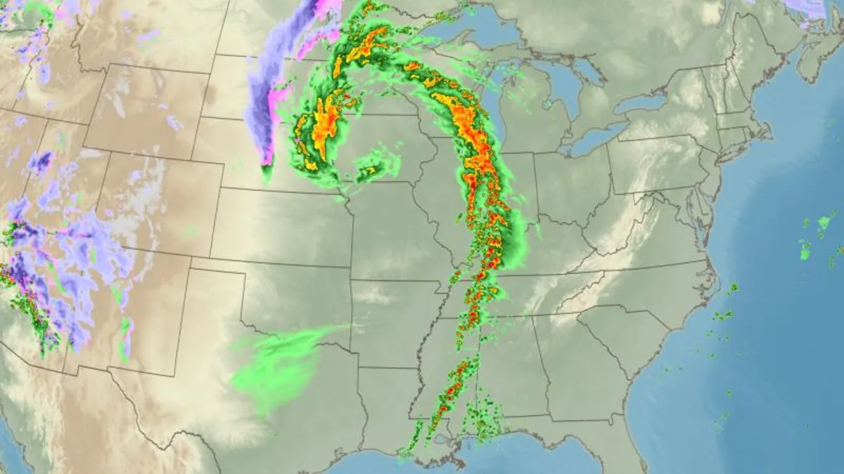
A significant cross-country storm is expected to intensify as it moves across the central United States this Friday, unleashing extreme weather conditions that will affect millions throughout the weekend. The storm is projected to bring the risk of multiple strong tornadoes, alongside a widespread outbreak of severe thunderstorms particularly across the Mississippi Valley and the South, starting Friday afternoon.
The primary event of this storm will be a severe thunderstorm outbreak that could span over 900 miles, affecting regions from Louisiana to Minnesota. As the storm intensifies late Friday afternoon, nearly 11 million people are at risk from central Iowa to northern Mississippi. Major cities like Des Moines, St. Louis, and Memphis are included in this high-risk area, categorized as a level 4 out of 5 for severe thunderstorms.
Surrounding areas, including Chicago, Kansas City, and Jackson, Mississippi, are also under a level 3 risk. The storms are expected to generate damaging winds with gusts potentially reaching hurricane-strength speeds of up to 100 mph. Residents should prepare for rapidly changing weather conditions, which can escalate from calm to severe thunderstorms in mere minutes.
The threat of tornadoes is particularly concerning, with the potential for strong EF2-rated tornadoes affecting over 6 million people from western Illinois and southeastern Missouri down to northwestern Tennessee and northern Mississippi. The National Weather Service emphasizes that nighttime tornadoes pose a significantly higher risk of fatalities, as they are harder to spot and prepare for.
On Saturday, the tornado threat escalates, particularly across eastern Louisiana, Mississippi, and Alabama, where a level 4 risk is again in place. The Storm Prediction Center warns of the possibility of numerous significant tornadoes, some potentially rated EF3 or higher, capable of causing extensive damage.
As the storm progresses, powerful winds will sweep across the central US, with gusts reaching up to 90 mph from New Mexico through the Plains. These winds are akin to a Category 1 hurricane and can lead to extensive property damage and hazardous travel conditions, particularly for large vehicles.
The winds will also exacerbate fire risks, with critical fire weather conditions rated level 3 of 3 in effect from Texas through Kansas. A rare “particularly dangerous situation” fire warning has been issued for parts of Kansas, predicting catastrophic conditions for grassland fires. Any ignition could rapidly escalate into a wind-driven inferno, especially given the ongoing drought conditions.
While the southern regions face severe thunderstorms, the northern side of the storm will bring its own set of challenges. From Friday night onward, snow, potentially mixed with ice, will begin to accumulate in the north-central US. Although most areas will see only a few inches, strong winds will result in blowing and drifting snow, leading to dangerous blizzard conditions.
These hazardous conditions can severely reduce visibility, making travel treacherous. Cities like Minneapolis are expected to experience a dramatic shift in weather, with severe thunderstorms transitioning to snow as temperatures drop significantly.
As this developing storm system approaches, it is crucial for residents in the affected areas to stay informed and prepared. The National Weather Service advises having multiple methods to receive warnings, especially during nighttime hours. Knowing where to seek shelter in the event of a tornado warning is essential for ensuring safety.
With the potential for severe thunderstorms, tornadoes, and blizzard conditions, this weekend promises to deliver a wide range of extreme weather experiences across the central United States. Stay tuned for updates as this situation evolves.