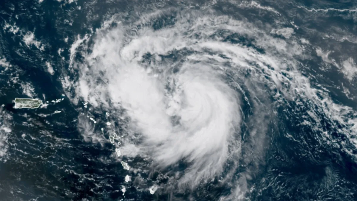
Newly designated Hurricane Erin is expected to churn through the waters of the Atlantic for at least a week, moving in a westward and northward direction. Forecasts indicate that Erin could strengthen into a major hurricane, potentially reaching Category 3 or higher for a minimum of three days, with predictions of peaking as a Category 4 hurricane as it traverses the unusually warm waters situated between The Bahamas and Bermuda.
Erin's expansive circulation is anticipated to bring days of heightened surf, significant beach erosion, and dangerous rip currents extending from the Greater Antilles to The Bahamas, Bermuda, and the Southeast U.S. coast. Eventually, these effects are expected to spread northward towards Atlantic Canada. As of 11 a.m. EDT on Friday, August 15, Erin had reached minimum hurricane strength, boasting sustained winds of 75 mph and a central pressure of 996 millibars. The storm was positioned approximately 460 miles east of the northern Leeward Islands, moving west-northwest at 18 mph.
While landfall is not expected in the northern Leewards, tropical storm watches have been issued across most of these islands. The weaker left-hand side of Erin may still produce winds near tropical storm strength, along with locally heavy rainfall that could trigger flash flooding.
Erin marks the first hurricane of the Atlantic season, following four relatively weak tropical storms. Statistically, based on the average from 1991-2020, the season's first hurricane typically develops around August 11, making Erin just four days "late." Notably, hurricanes have been forming earlier in the season for over a decade. The last occurrence of the first hurricane forming after this climatological average date was in 2013 with Hurricane Humberto, which reached hurricane strength on September 11.
As of midday Friday, Erin was already displaying impressive hurricane characteristics. It is believed that its development could have accelerated even faster had it not been for the presence of Saharan dust and dry air that initially infiltrated its well-defined circulation. By Friday, showers and thunderstorms were gradually consolidating around Erin's core, with squalls extending well to the west and north. Conditions are becoming increasingly favorable for Erin to intensify into a formidable hurricane.
The mid-level atmosphere surrounding Erin is expected to become more humid over time, with relative humidity increasing from around 55 percent on Friday to approximately 65 percent early next week. Erin's robust circulation should help it withstand potential negative impacts from the expected strong wind shear (10-20 knots) that will prevail from late weekend into early next week. Furthermore, Erin will be traversing exceptionally warm water, with sea surface temperatures rising from about 28-29 degrees Celsius (82-84 degrees Fahrenheit) on Friday to around 30°C (86°F) by early next week. These temperatures are up to 1-2°C (2-4°F) warmer than the average for mid-August, significantly influenced by human-caused climate change.
The Friday morning forecast from the National Hurricane Center indicates a potential period of rapid intensification from Friday evening to Saturday evening, during which Erin is predicted to reach Category 3 status with top sustained winds of 120 mph. Despite increased wind shear anticipated later in the weekend, forecasters still expect Erin to achieve Category 4 strength by late Sunday and potentially maintain its status as a major hurricane through midweek.
The SHIPS statistical model indicates a 23% chance of Erin gaining 30 knots of strength within 24 hours, which is significantly higher than the climatological norm. The newer DTOPS model predicts even greater odds, at 48%.
As we approach the peak of the Cabo Verde season, several disturbances are already forming, with the potential for at least one of these systems to develop next week as it crosses the Main Development Region of the tropical Atlantic. Long-range ensemble models, particularly the GFS, suggest that this upcoming system—should it develop—would track at a lower latitude than Erin. Residents from the Leeward Islands to the Greater Antilles should stay alert, as such developments could impact these areas as soon as next weekend (August 23-24).
Meanwhile, a disturbance in the western Gulf, referred to as Invest 98L, has been producing showers and thunderstorms as it approaches the southern Texas coast. Hurricane hunters have detected no low-level circulation in this system, and the National Hurricane Center has assigned it a near-zero chance of development in its latest Tropical Weather Outlook.