An extremely dangerous heat wave is currently impacting the eastern half of the United States as a potent heat dome reaches its peak. This meteorological phenomenon is bringing some of the hottest temperatures recorded this year, with forecasts indicating that many cities will experience their hottest temperatures in years. Tens of millions of people are at risk, prompting urgent heat alerts across the region.
During the peak of this heat wave on Monday and Tuesday, it is projected that over 250 daily temperature records could be shattered. These records include both record highs and record warm lows, with some locations possibly experiencing temperatures that are “the hottest observed in over a decade,” according to the National Weather Service in Mount Holly, New Jersey. Additional records may continue to fall on Wednesday and Thursday as the oppressive heat lingers.
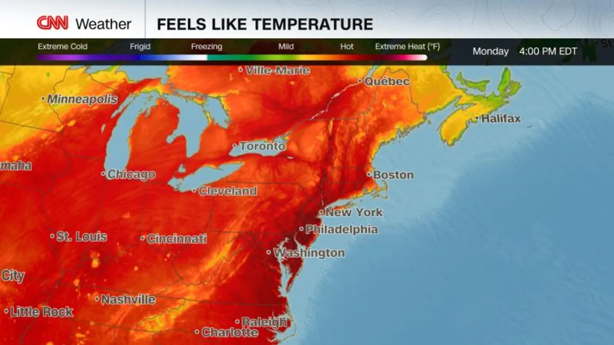
On Monday, around 150 million people are under heat alerts, according to the National Weather Service. Many areas will feel more like July, traditionally the hottest month of summer, than June, as temperatures are expected to rise 15 to 20 degrees above normal. A level 4-of-4 extreme heat risk is in effect through at least Thursday, stretching from the Midwest to the Mid-Atlantic and impacting parts of the Northeast.
This prolonged heat event is rare and is likely to provide little to no overnight relief. The National Weather Service warns that this situation will affect “anyone without effective cooling and/or adequate hydration.” Heat-related illnesses tend to increase significantly during extreme heat and high humidity events, posing life-threatening risks, especially for children, the elderly, and individuals with pre-existing health conditions.
The dangerous impacts of this heat wave were felt immediately as sizzling conditions ramped up in the central U.S. over the weekend. Notably, multiple individuals, including a Major League Baseball player, an umpire, and a staff member, were treated for heat-related illnesses during a game between the Seattle Mariners and the Chicago Cubs at Wrigley Field in Chicago. The temperature soared into the mid-90s, but with humidity, it felt more like 105.
Heat remains the deadliest form of extreme weather in the U.S., with the frequency and duration of extreme heat waves on the rise in recent years, attributed largely to human-caused climate change. Notably, nighttime temperatures are warming faster than daytime highs, exacerbating the impact of these heat events.
The hazardous heat is expected to spread into the East, reaching a fever pitch on Monday and Tuesday. For instance, New York City could break its daily high-temperature records on both days, with temperatures soaring into the mid-to-upper 90s. A staggering 100 degrees could be recorded on Tuesday, a mark that hasn’t been seen in the city in June since 1966.
Other cities along the I-95 corridor are also bracing for extreme heat. Philadelphia is forecasted to hover near 100 degrees from Monday through Wednesday, likely breaking daily high-temperature records consecutively. Washington, DC, will experience triple-digit temperatures during this period, breaking multiple records along the way. Typically, the nation’s capital doesn’t register its first 100-degree day until mid-July.
Even northern New England is not immune to the intense heat. Burlington, Vermont, could face one of its three hottest June days on record, with highs expected to reach the upper 90s, a temperature usually observed in mid-July.
While temperatures will begin to ease on Wednesday, especially for some in the Midwest and New England, Thursday is anticipated to mark a return to more normal June warmth for many in the eastern half of the country. This early-season heat wave may just be a preview of the extreme weather conditions that lie ahead.