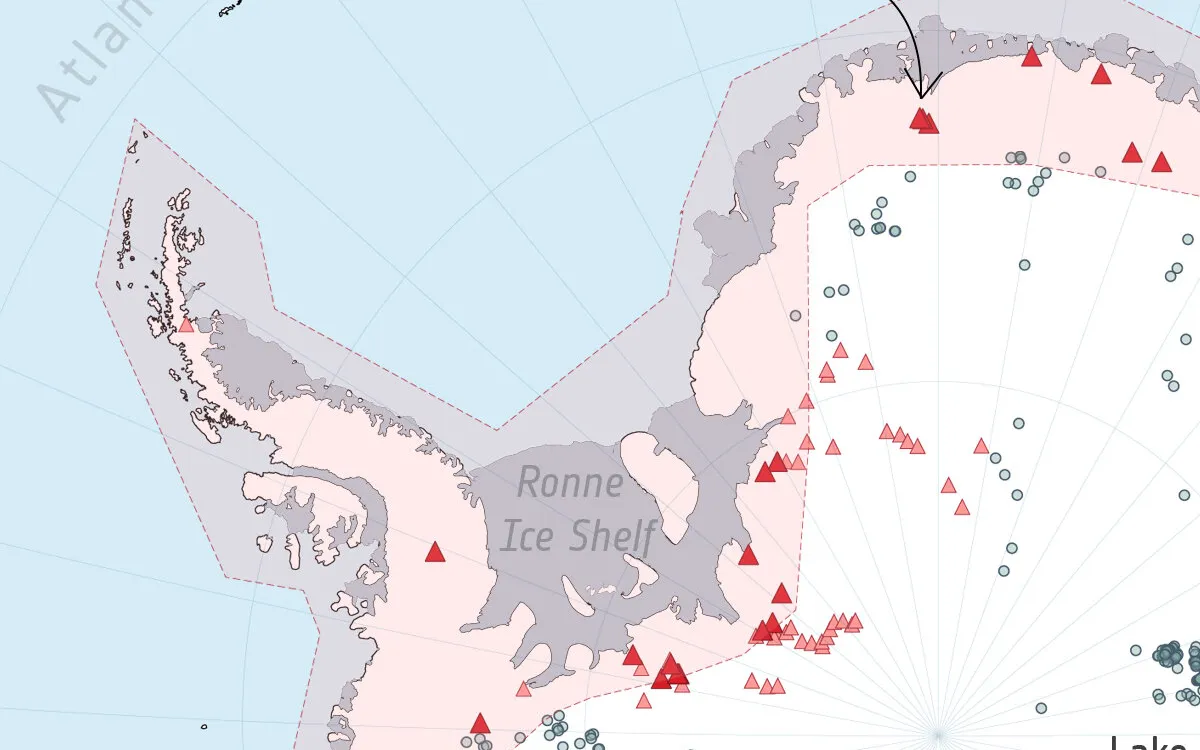
Hidden beneath the largest ice mass on Earth, the Antarctic ice sheet harbors hundreds of subglacial lakes that play a vital role in glacier movement and stability, significantly influencing global sea level rise. Recent research, utilizing a decade of data from the European Space Agency’s (ESA) CryoSat satellite, has unveiled 85 previously unknown lakes located several kilometers beneath the icy surface surrounding the South Pole. This groundbreaking discovery increases the total number of known active subglacial lakes in Antarctica by over 50%, bringing the total to 231.
The findings, published in the journal Nature Communications, are pivotal because active subglacial lakes drain and refill on a cyclical basis, providing rare insights into the processes occurring deep beneath the ice sheet's surface. The study also uncovered new drainage pathways, including five interconnected subglacial lake networks. Lead author Sally Wilson, a doctoral researcher at the University of Leeds, emphasized that understanding subglacial lakes and their water flow is challenging due to their burial under hundreds of meters of ice. “It is incredibly difficult to observe subglacial lake filling and draining events in these conditions, especially since they take several months or years to fill and drain,” Wilson explained. “Before our study, only 36 complete cycles had been observed worldwide. We documented an additional 12 complete fill-drain events, raising the total to 48.”
The contribution of satellites to this research cannot be overstated. The CryoSat mission, which was launched in 2010, has provided a comprehensive dataset spanning from 2010 to 2020. This satellite, part of ESA’s FutureEO programme, is designed to measure the thickness of polar sea ice and monitor changes in the height of ice sheets across Greenland and Antarctica, as well as glaciers worldwide. Its primary instrument, a radar altimeter, detects minute variations in the height of the ice surface and measures sea surface height.
By analyzing a decade's worth of observations from CryoSat, researchers identified localized changes in the height of Antarctica’s icy surface, which fluctuates as the subglacial lakes fill and drain. This capability enabled scientists to map these hidden lakes and monitor their filling and draining cycles over time. Co-author Anna Hogg, a professor at the University of Leeds, remarked, “It was fascinating to discover that the subglacial lake areas can change during different filling or draining cycles. This illustrates that Antarctic subglacial hydrology is much more dynamic than previously thought, necessitating ongoing monitoring of these lakes as they evolve.”
Understanding the dynamics of ice sheets is crucial for predicting future sea level rise. Sally Wilson noted that current numerical models used to project the impact of ice sheets on sea levels do not account for subglacial hydrology. "These new datasets of subglacial lake locations, extents, and timeseries of change will enhance our understanding of the processes driving water flow beneath Antarctica," she stated.
Martin Wearing, ESA Polar Science Cluster Coordinator, highlighted the significance of CryoSat data in advancing our comprehension of polar regions and the dynamics of ice sheets. “The more we understand about the complex processes affecting the Antarctic Ice Sheet, including the flow of meltwater at its base, the more accurately we will be able to project future sea level rise,” he emphasized.
Subglacial lakes form when meltwater accumulates due to geothermal heat from the Earth’s bedrock and frictional heat generated as ice slides over the bedrock. This meltwater can pool on the bedrock surface and periodically drain. Such water flow can reduce friction between the ice and the underlying bedrock, enabling faster movement of ice into the ocean.
While many subglacial lakes are considered stable and do not fill or drain, the largest known subglacial lake is Lake Vostok, located beneath the East Antarctic Ice Sheet. This lake holds an estimated 5,000 to 65,000 cubic kilometers of water beneath 4 kilometers of ice, enough to fill the Grand Canyon and overflow by at least 25%. Although Lake Vostok is thought to be stable, a potential drainage event could destabilize the Antarctic Ice Sheet, impacting surrounding ocean circulation, marine habitats, and global sea levels.
The cycles of filling and draining in subglacial lakes provide critical data for ice sheet and climate models. Monitoring these phenomena allows scientists to deepen their understanding of the interactions between ice sheets, bedrock, ocean, and atmosphere, which is essential for assessing the future stability of ice sheets. “Subglacial hydrology is a missing piece in many ice sheet models,” Sally Wilson stated. “By mapping where and when these lakes are active, we can quantify their impact on ice dynamics and improve projections of future sea level rise.”